Ocean Survey 20/20 Resumes
Hopes are high that marine life previously unrecorded in New Zealand will be found during the second phase of the three-vessel Ocean Survey 20/20 Bay of Islands project. The survey...
Hopes are high that marine life previously unrecorded in New Zealand will be found during the second phase of the three-vessel Ocean Survey 20/20 Bay of Islands project. The survey...
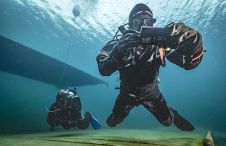
The innovative system facilitates map-based navigation for divers on a mission, offering the flexibility of seamless two-way communication between divers and the dive supervision team, as well as pre-mission and...
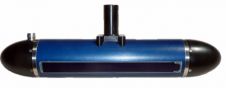
Ping DSP (Canada) has named SUBSEA 20/20 as the first sales agency to represent their new line of 3D Sidescan sonar systems. After several years of research, product development and...

Collaborating and coordinating are two very important tasks of EuroGOOS, the European Global Ocean Observing System, located in Brussels. The member organizations work together to share ocean observation data and...

SEA-KIT International, a leading designer and builder of uncrewed surface vessels (USVs), achieved a significant milestone in 2021 when it received the first-ever Unmanned Marine Systems (UMS) certificate from Lloyd’s...

Between January 2023 and February 2024, TDI-Brooks, a specialized company in geotechnical and offshore survey projects, conducted an extensive site investigation programme across two offshore wind blocks in state and...
This month's theme is hydrography and living resources. However, you won't find any articles on the subject in this magazine. A bit strange coming from me, who for years worked...

Geospatial cloud specialist north.io has announced it aims to revolutionize the modelling, collection and processing of ocean data using NVIDIA technologies. According to Jann Wendt, CEO, north.io, the synergy between...

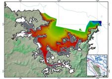
By harnessing capabilities of advanced satellite technology and ever-evolving data analysis, satellite-based mapping (including satellite-derived bathymetry, SDB) offers an efficient, extensible and cost-effective method for mapping water properties, underwater topography...
This site uses cookies. By continuing to use this website, you agree to our Cookies Policy. Agree