Waterside Mapping
Laser scanning and bathymetric side-scan sonar represent the cutting edge of environmental survey technology. Over the last few years, we have tested the integration of these two methodologies, carrying out...
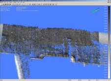
Laser scanning and bathymetric side-scan sonar represent the cutting edge of environmental survey technology. Over the last few years, we have tested the integration of these two methodologies, carrying out...
RSI, a wholly owned subsidiary of ITT Industries, today announced it has signed an agreement with Tech-X Corporation of Boulder, Colorado, to offer Tech-X’s cluster computing solutions to IDL users...
First-timers teams were the ones to beat at this summer's sixth annual international student ROV competition. In an event that highlighted the International Polar Year, the winners were participants Jesuit...
On Friday 8 June 2007, the bulk carrierPasha Bulkerran aground in heavy storm conditions on one of Newcastle’s most famous surfing beaches, Nobbys, near the entrance to Newcastle Harbour in...
Foreword by Steve Ritchie Until 1959 the two triangulation networks on either side of the Persian Gulf had never been connected, so that ships’ navigators, when changing their fixes from...
On 8th October 1993, with the introduction of the Laser Airborne Depth Sounder (LADS) flown in a Fokker F-27 aircraft, the Australian Hydrographic Service could claim to be among the...
ECDIS has been standardised by the IHO in Special Publications No. 57 (S57) and No. 52 (S52) and is established in coastal and open sea areas. The S57 standard covers...
ECDIS has been standardised by the IHO in Special Publications No. 57 (S57) and No. 52 (S52) and is established in coastal and open sea areas. The S57 standard covers...
What started out as a small niche company specialising in hydrographic multi-beam surveys has really taken flight since 1992. C&C Technologies has been led in many other directions than multi-beam...
Within the last twenty years Global Positioning System (GPS) receivers have revolutionised navigation. Integrated devices are capable of providing time, position, height, direction, heave and attitude to accuracies of a...
This site uses cookies. By continuing to use this website, you agree to our Cookies Policy. Agree