Jumbo Display
Knowing how much and how fast cable is heaved in or paid out can be crucial for controlling underwater equipment, but standing next to the winch to view a display...
Knowing how much and how fast cable is heaved in or paid out can be crucial for controlling underwater equipment, but standing next to the winch to view a display...
Seatronics and OceanWise (UK) have jointly been awarded a contract by Ras al-Khaimah Port, United Arab Emirates for the supply and support of a tidal monitoring, telemetry and display system,...

A major announcement was made this year by the International Maritime Organisation (IMO) who has set the schedule for mandating the use of electronic chart display and information system (ECDIS)....
S-101 is the new product specification for Electronic Navigational Chart (ENC) datasets based on the overarching S-100 framework standard of the International Hydrographic Organization (IHO). The development of S-101 is...
By Roosmarijn Haring Safety of navigation is essential for the protection of lives and the environment. This is the basic premise of the United Nations (1974) proclamation entitled SOLAS...
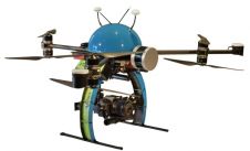
The NEXUS 800 powered by HYPACK is a full end-to-end solution representing a new paradigm in unmanned aerial vehicle (UAV) data collection by harmonising Lidar data with photogrammetry. The NEXUS...
Sperry Marine North American Support Center in Harvey (LA, USA) is now authorised to perform Level III repair and calibration of Hatteland flat-screen monitors for electronic chart display and information...
The C-Nav GPS Division of C & C Technologies has updated the popular C-NaviGator, a GNSS Control and Display unit. The updates include a new high-performance, touch screen version featuring...
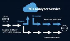
SevenCs has announced the launch of its 7Cs Analyzer Service Application Programming Interface (API). Chart producers and hydrographic offices of all sizes can use this new API to activate the...
UTEC Survey is now well into the first phase of its hydrographic survey of offshore Dubai. Work began at the beginning of October 2008 and the processing and hand-over of...
This site uses cookies. By continuing to use this website, you agree to our Cookies Policy. Agree