Marine GIS Workshop
OceanWise, UK, is to host its annual Marine GIS Workshop on Tuesday 18 November 2014 at The School for Economic Science in Mandeville Place, London, W1U 3AJ. Existing customers will...
OceanWise, UK, is to host its annual Marine GIS Workshop on Tuesday 18 November 2014 at The School for Economic Science in Mandeville Place, London, W1U 3AJ. Existing customers will...
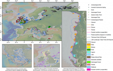
EMODnet Geology has updated the ‘Submerged Landscapes’ data product. This fully attributed GIS layer now comprises more than 16,000 features representing 27 classes of submerged landscape and palaeoenvironmental indicators, including...
OceanWise, a renowned provider of marine and coastal mapping worldwide, has been awarded the framework agreement for the provision of GIS marine data to the Scottish Government until 2026. Janet...
The 2010 ESRI User Conference is to be held from 12th to 16th July 2010 in San Diego (CA, USA). GIS users are encouraged to share their best practices, successes...
From now on, GIM International is your guide for GIS software. On this website, you will find a guide to GIS software that is available to download for free. Follow...
AvisMap has launched GIS Engine a SDK designed for custom GIS applications. It facilitates custom development of GIS solutions and applications. This SDK provides several ActiveX (OCX) controls which support...
This article is an adaptation of a lecture presented last February to the Benelux Branch of the Hydrographic society in Delft, The Netherlands. The main question addressed in this lecture...
‘It is a curious situation that the sea, from which life first arose, should now be threatened by the activities of one form of that life. But the sea, though...
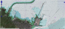
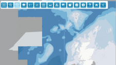
OceanWise, UK, has developed a set of specialist tools and methodologies to identify specific content from raster charts. By removing all content to the landward side of the coastline, OceanWise...
This site uses cookies. By continuing to use this website, you agree to our Cookies Policy. Agree