Scientists reveal pristine ecosystems on high seas seamounts
An international expedition to the Salas y Gómez Ridge has uncovered 160 species, potentially including 50 new to science. Led by Dr Erin E. Easton and Dr Javier Sellanes, the...

An international expedition to the Salas y Gómez Ridge has uncovered 160 species, potentially including 50 new to science. Led by Dr Erin E. Easton and Dr Javier Sellanes, the...

Collaborating and coordinating are two very important tasks of EuroGOOS, the European Global Ocean Observing System, located in Brussels. The member organizations work together to share ocean observation data and...

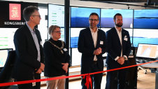
Ocean surveying and inspection specialist Argeo Subsea, CSI Nordics and Kongsberg Discovery have formalized a three-party Certificate of Delivery and Acceptance for an advanced HUGIN Superior AUV. This milestone agreement,...

Geospatial cloud specialist north.io has announced it aims to revolutionize the modelling, collection and processing of ocean data using NVIDIA technologies. According to Jann Wendt, CEO, north.io, the synergy between...

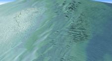
By harnessing capabilities of advanced satellite technology and ever-evolving data analysis, satellite-based mapping (including satellite-derived bathymetry, SDB) offers an efficient, extensible and cost-effective method for mapping water properties, underwater topography...

In an era of great power competition, unmanned maritime systems (UMSs) have begun to take centre stage and are now on an accelerated development path for reasons that are clear....
Teledyne Geospatial has announced that Tetra Tech, a leading provider of high-end consulting and engineering services, recently acquired a Teledyne Optech CZMIL SuperNova Topobathymetric Lidar system. Tetra Tech has successfully...
Teledyne Technologies has entered into an agreement to acquire Valeport Holdings Limited and its affiliates (“Valeport”). Established as a dynamic company in 1969 and headquartered in Totnes, United Kingdom, Valeport...
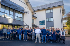
Autonomous vessel operations company Massterly has opened its Remote Operations Centre (ROC) in Horten, Norway. This significant step marks a crucial transition from the testing phase to fully-fledged operational capabilities...

In the quest to unravel the mysteries beneath our planet’s water bodies, topobathymetric technologies emerge as a beacon of innovation. Among them, Lidar (light detection and ranging) and sonar sensors...
This site uses cookies. By continuing to use this website, you agree to our Cookies Policy. Agree