Dredging Point-cloud Software
Charting underwater structures, soils and project progression using GPS, sonar, single and multibeam systems produces a huge amount of data that needs to be analysed. Vast project areas can be...
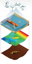
Charting underwater structures, soils and project progression using GPS, sonar, single and multibeam systems produces a huge amount of data that needs to be analysed. Vast project areas can be...
The planned widening of the Dutch Maas river (Meuse) represents a landscape correction that will prevent future flooding. Gravel barriers are being prepared in order to buffer any additional flow....
This site uses cookies. By continuing to use this website, you agree to our Cookies Policy. Agree