Port of London Authority Inks Deal on New Catamaran Survey Vessel
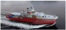
The Port of London Authority (PLA, UK) has sealed a deal to put a new purpose-built survey catamaran on the River Thames to replace its existing survey vessel Yantlet. The...
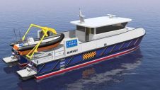
The Port of London Authority (PLA, UK) has sealed a deal to put a new purpose-built survey catamaran on the River Thames to replace its existing survey vessel Yantlet. The...
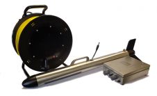
Kongsberg Maritime, Norway, has introduced a tow fish sidescan sonar for use in search and recovery (SAR) missions as well as underwater inspection, engineering and scientific surveys. Developed by Kongsberg...
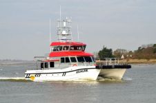
The first two-deck boat ever built by UK-based Blyth Workcats has recently been delivered to a customer in Belgium, Ostend Marine Services. The 18-metre Aqualink is the first Blyth Workcat...

The Port of Rotterdam is Europe’s largest port and is one of the world’s key logistic hubs. Hydrographic data is critical to the Harbour master’s department for the operation of the Port of Rotterdam, to support the nautical accessibility of the deep-sea vessels by electronic nautical chart. The introduction of PortMaps enables the Port of Rotterdam to produce a wide variety of information products, including ENCs, from the Port’s survey data, in less than 48 hours. With over 500 line connections to and from more than 1,000 ports around the globe, the Port of Rotterdam in The Netherlands is the cornerstone of international freight transport. It is the...
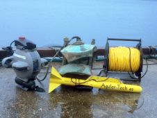
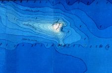
On 22 June 2015, after a six-year-long search for the sunken German warship Rio de Janeiro, the companies Agder-Tech, Adykk and Seabed Services found the vessel sitting off the coast...
It is hardly possible to discuss the configuration of the deep ocean bed without eventually using the term ‘seamount’. Today, the existence of tens of thousands if not over 100,000 seamounts...
The Peruvian Navy, Directorate of Hydrography and Navigation is realising a hydrographic and oceanographic vessel, designed and built by Freire shipyard in Vigo, Spain. Its structural design achieves the Polar...
Seabed survey contractor Bibby HydroMap completed geophysical, geotechnical, benthic and land survey operations along the route from mainland Scotland to the Isle of Lewis, UK, on behalf of client SHE...
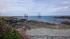
Fugro has commenced marine site characterisation works for Horizon Nuclear Power at the proposed Wylfa Newydd power station site on the Isle of Anglesey, UK. The detailed works are carried...
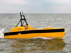
ASV Global has reached the landmark of 1,000 days of unmanned operations. The milestone was reached during the Unmanned Warrior 2016 event which saw more than 50 unmanned vehicles operating...
This site uses cookies. By continuing to use this website, you agree to our Cookies Policy. Agree