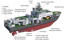
The Making of RV Kronprins Haakon
Norway is a maritime country with a very long coastline. It is also very much a polar nation, with 80% of its sea territory and 45% of its land mass...
Norway is a maritime country with a very long coastline. It is also very much a polar nation, with 80% of its sea territory and 45% of its land mass...

Hemisphere GNSS has introduced the all-new Vector V1000 GNSS receiver, which provides high-accuracy heading, position, pitch, roll and heave data. The V1000 supports multi-frequency GPS, GLONASS, BeiDou, Galileo, QZSS and...

At this year’s Oceanology International in London, UK, SBG Systems released the Navsight Marine Solution, a full high-performance inertial navigation solution designed to make surveyors’ tasks easier in both shallow...
Nexans Olex has successfully integrated Spatial, an inertial navigation system, into its hydrographic vessel. Spatial is a ruggedised miniature GPS-aided inertial navigation system and AHRS that provides accurate position, velocity, acceleration...
For many years, the GeoSwath system from Kongsberg GeoAcoustics has provided an efficient simultaneous swath bathymetry and sidescan seabed mapping solution with accuracies that meet the IHO S-44 Special Order...
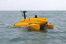
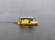
ASV Global has delivered a 3m autonomous catamaran to the University of Southampton, UK. This vessel is the first of the C-Cat vessels to roll off the production line. The...

Seventeen underwater robotic dives have been made using ROV SuBastian, completing the first expedition of the islands and eastern seamounts of the Phoenix Islands Protected Area (PIPA) in the nation...
Deep Ocean Engineering is introducing a small remotely operated vehicle (ROV) system for the ARIS sonar, complete with a tilt and roll actuator. While the system is operating, the sonar...

Sonardyne International Ltd, UK, has been awarded the contract to supply Britain’s new polar research vessel, RRS Sir David Attenborough, with subsea acoustic tracking and position reference equipment. The Ranger...

Production seafloor surveys for hydrography require careful planning, balancing many factors for operational efficiency. Requirements for meeting International Hydrographic Organization (IHO) standards for horizontal and vertical uncertainty and object detection...
This site uses cookies. By continuing to use this website, you agree to our Cookies Policy. Agree