Andrew Wheeler
Andrew Wheeler is Professor of Geology and head of Geology at University College Cork. As a marine geologist, he works on both shallow and deepwater systems with interests in seabed...

Andrew Wheeler is Professor of Geology and head of Geology at University College Cork. As a marine geologist, he works on both shallow and deepwater systems with interests in seabed...

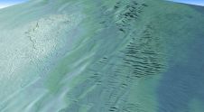
The Marine Geoscience Research Group at University College Cork, under the aegis of the Irish Marine Institute, has published the first high-resolution geomorphological map of most of the Irish continental...

Between January 2023 and February 2024, TDI-Brooks, a specialized company in geotechnical and offshore survey projects, conducted an extensive site investigation programme across two offshore wind blocks in state and...

By harnessing capabilities of advanced satellite technology and ever-evolving data analysis, satellite-based mapping (including satellite-derived bathymetry, SDB) offers an efficient, extensible and cost-effective method for mapping water properties, underwater topography...
Teledyne Geospatial has announced that Tetra Tech, a leading provider of high-end consulting and engineering services, recently acquired a Teledyne Optech CZMIL SuperNova Topobathymetric Lidar system. Tetra Tech has successfully...
The establishment of multi-beam echo sounders (MBES) as a mainstream tool in ocean mapping has revolutionised approaches towards nautical charting, seafloor geotechnical/geological surveys and benthic habitat mapping. The resolution of...
EIVA, Denmark, has entered into a partnership with the College of Charleston and University of Washington, USA, on the benthic acoustic mapping and survey (BEAMS) programme. This joint journey will...
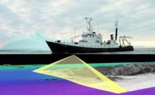
The South African Council for Geoscience recently launched an initiative to optimize marine geophysical data collection in South African waters. The main aim of the initiative is to produce marine...
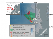
World oceans host diverse creatures that shape the seafloor. In a groundbreaking interdisciplinary study published in Communications Earth & Environment, Kiel University geoscientists, alongside biology and oceanography experts, have linked...
This site uses cookies. By continuing to use this website, you agree to our Cookies Policy. Agree