GeoChirp 3D Imaging
The GeoChirp 3D from GeoAcoustics Ltd provides the shallow-survey market with a new tool to image sub-surface structures and buried objects. The GeoChirp 3D provides a three-dimensional image of the...
The GeoChirp 3D from GeoAcoustics Ltd provides the shallow-survey market with a new tool to image sub-surface structures and buried objects. The GeoChirp 3D provides a three-dimensional image of the...
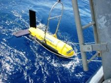
C&C Technologies recently completed a survey for Noble Energy utilising its new C-Surveyor III AUV. The C-Surveyor III completed the 81NM survey in the Gulf of Mexico with water depths...
A method is presented which greatly increases the efficiency of pipeline survey using sediment echo sounder. These surveys are mostly done sailing cross courses; adding receiving directionality, a course can...

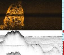
StarFish is a high-definition seabed imaging sonar, launched by Tritech during Oceans 2007 in Aberdeen (UK). Producing near photo-quality images of the seabed it's according to Tritech the smallest towfish...

Geoacoustics recently delivered two complete Geoacoustics Deep Tow 2000 combined chirp- and sidescan sonars systems to the Hong Kong-based survey company EGS. The system is interfaced to C-View-software, a specially...
An EdgeTech 2400-DSS deep-towed side-scan sonar system, owned and operated by Odyssey Marine Exploration, was used to find a shipwreck code-named the "Black Swan" which yielded over 500,000 silver and...
L-3 Klein has launched a CHIRP Sub Bottom Profiler (SBP) attachment for the 3000 Model Side-scan Sonar. The older SBP was a single transducer 3.5kHz "pinger" and delivered satisfactory performance...
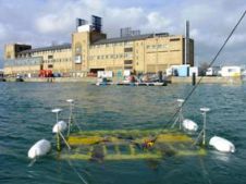
The ninth Unmanned Underwater Vehicle Showcase took place at the National Oceanography Centre (NOC), Southampton, from 26th to 27th September 2007. This conference/exhibition is one of the few (and in...

Fugro has signed an agreement with ship designers and builders, Fr. Fassmer GMBH & Co. KG of Bremen (Germany), for the design and construction of a new geophysical survey vessel....
There is quite a difference between land surveyors (topographers) and those who survey at sea. Topographers can generally gather their information by direct observation and measurement, whereas hydrographic surveyors have...
This site uses cookies. By continuing to use this website, you agree to our Cookies Policy. Agree