Marine & Coastal Civil Engineering (M&CCE) Expo

In the quest to unravel the mysteries beneath our planet’s water bodies, topobathymetric technologies emerge as a beacon of innovation. Among them, Lidar (light detection and ranging) and sonar sensors...

Oceanology International 2024 (Oi24) is set to captivate attendees with a showcase of pioneering companies and innovative technologies, all poised to command attention at London's ExCeL. From advanced autonomous vehicles...
Lidar, short for Light Detection and Ranging surveying, represents a sophisticated measuring system leveraging the power of light. Widely recognized for its versatility, Lidar is extensively applied in diverse fields...
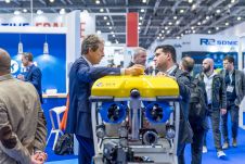
With innovation, progress and discovery at its heart, Oceanology International 2024 (Oi24) is preparing to welcome the world’s largest gathering of ocean professionals to the most powerful and inspirational event...
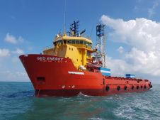
PDE Offshore Corporation, a leading Taiwanese company specializing in offshore geophysical and geotechnical investigations, recently upgraded its underwater acoustic positioning system on its MV Geo Energy to Sonardyne’s advanced Ranger...

When contemplating the replacement of a research and survey fleet, a collective effort is required to meticulously curate an optimal new fleet, considering factors such as ship type, size, capabilities...

The UK’s Maritime and Coastguard Agency (MCA) is the national authority responsible for implementing the British Government’s maritime safety policy. Within this remit, the MCA is accountable for delivering national...
This site uses cookies. By continuing to use this website, you agree to our Cookies Policy. Agree