EMODnet Geology updates seabed maps for EU and Caribbean
EMODnet Geology is extending its offer with new and updated data products on seabed substrate maps for EU waters and the Caribbean Sea and seabed erosion. The European Marine Observation...

EMODnet Geology is extending its offer with new and updated data products on seabed substrate maps for EU waters and the Caribbean Sea and seabed erosion. The European Marine Observation...
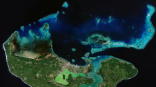
Coastal zones, situated at the intersection of land and ocean, hold immense social, economic and ecological significance. Currently, nearly 40% of the global population resides within 100km of the coast,...
Cadcorp is a British software development company focused on geographic information systems (GIS) and web mapping software. From its headquarters in Stevenage, UK, Cadcorp is growing both its direct and...
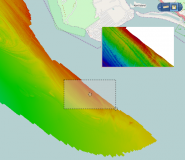
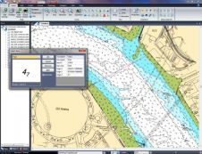
The latest release of Spatial Fusion Enterprise builds on its support of Open Geospatial Consortium (OGC) standards by implementing the Web Coverage Service (WCS) standard for bathymetric data. The new...
CARIS has released Spatial Fusion Enterprise (SFE) version 5.3 featuring the new Web Map Tile Service (WMTS). SFE allows an organisation to deliver its geospatial information to the Web using...
This site uses cookies. By continuing to use this website, you agree to our Cookies Policy. Agree