Andrew Wheeler
Andrew Wheeler is Professor of Geology and head of Geology at University College Cork. As a marine geologist, he works on both shallow and deepwater systems with interests in seabed...
Andrew Wheeler is Professor of Geology and head of Geology at University College Cork. As a marine geologist, he works on both shallow and deepwater systems with interests in seabed...

Riccardo Arosio is a marine geologist and postdoctoral researcher at University College Cork in the Marine Geosciences Research Group. Riccardo’s research focuses on the use of geomorphometry and machine learning...

The Marine Geoscience Research Group at University College Cork, under the aegis of the Irish Marine Institute, has published the first high-resolution geomorphological map of most of the Irish continental...

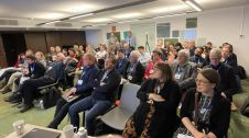
Between January 2023 and February 2024, TDI-Brooks, a specialized company in geotechnical and offshore survey projects, conducted an extensive site investigation programme across two offshore wind blocks in state and...
EMODnet Geology is extending its offer with new and updated data products on seabed substrate maps for EU waters and the Caribbean Sea and seabed erosion. The European Marine Observation...
Lidar, short for Light Detection and Ranging surveying, represents a sophisticated measuring system leveraging the power of light. Widely recognized for its versatility, Lidar is extensively applied in diverse fields...
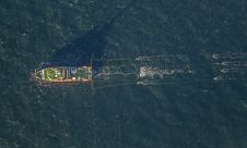
Fugro has secured the geophysical survey contract for the Dutch Doordewind offshore wind farm zone development. Fugro’s selection was driven by its pioneering 2D ultra-ultra-high resolution (UUHR) surveys, delivering unparalleled...
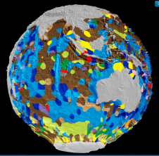
Scientists from the University of Sydney’s School of Geosciences, Australia, have led the creation of the world’s first digital map of seafloor geology. Before then, the most recent map of...
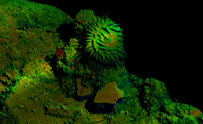
Voyis, a pioneer in optical solutions for subsea vehicles, has announced its work with Memorial University of Newfoundland on an extraordinary scientific expedition to the Galápagos Islands, funded by Schmidt...
This site uses cookies. By continuing to use this website, you agree to our Cookies Policy. Agree