Educational Institutes Need to Reach Out in Co-operation
Brest is the biggest supplier of highly qualified hydrographers in Europe with more than 30 graduates per year and growing. Can you explain the success of ENSTA? The success of...

Brest is the biggest supplier of highly qualified hydrographers in Europe with more than 30 graduates per year and growing. Can you explain the success of ENSTA? The success of...
Lantmäteriet, the Swedish mapping, cadastral and land registration authority, has invested in an UltraCam Eagle 'ultra-large' format digital aerial camera system. It will be used to support Lantmäteriet’s national aerial...
The RIEGL VQ-820-G has won the Geospatial Excellence Award in the Technology Innovation category at the MAPPS/ASPRS 2012 Specialty Conference. The VQ-820-G introduced the world's first 'tightly coupled', shallow-water, land...
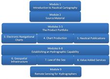
The Challenge: To provide a stimulating educational framework that blends relevant theory with practical exercises without removing individuals from their work environment for too long a period and optimising investment...
The third session of the UN Committee of Experts on Global Geospatial Information Management (UN-GGIM) took place in Cambridge, UK, from 24 to 26 July 2013. Over 70 UN Member...
SPAR Point Group, organiser of SPAR Europe 3D Measurement & Imaging Conference and European Lidar Mapping Forum (ELMF), has announced a Call for Papers for the 2013 events which will...
Thanks to a recent initiative of the ASPRS Lidar Division, different segments of the Lidar mapping community now have the ability to customise the LAS file format to meet their...

The Great East Japan Earthquake and Tsunami of 11 March 2011 measuring 9.0 on the Richter scale caused the meltdown and melt through of three reactors at Fukushima No.1 Nuclear...

In the summer of 2013, several companies and individuals volunteered to conduct a hydrographic survey off the D-Day beaches of Normandy, France. The first phase of the survey was conducted...
Subsea metrology is the process of acquiring accurate measurements for the connection of subsea structures and pipelines. IMCA’s guidance covers the most commonly used techniques today. These are long baseline...
This site uses cookies. By continuing to use this website, you agree to our Cookies Policy. Agree