A Software Perspective
The field of hydrography is poised to make some substantial contributions to the unmanned systems community. The mantra of ‘making a map is easy, but doing hydrography is hard positions...

The field of hydrography is poised to make some substantial contributions to the unmanned systems community. The mantra of ‘making a map is easy, but doing hydrography is hard positions...
Veripos, UK, has extended its range of proprietary software with the introduction of Quantum, a suite of visualisation modules providing a user interface for delivery of next-generation services and features....

Veripos has introduced version 7 of its Quantum software incorporating GNSS Resilience and Integrity Technology (GRIT) firmware from Hexagon’s Autonomy & Positioning division to enhance resistance to interference, jamming and...
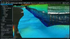
NaviModel 4 by EIVA, Denmark, includes a free viewer, the completion of laser scanner data implementation throughout the data acquisition and processing workflow covered by the EIVA NaviSuite products, and...
C-Nav, USA, has introduced an upgraded version of its C-Scape software. The updated software includes enhanced control functions for all C-Nav receivers, improved AutoCAD support and advanced graphics capabilities. Enhancements,...
This site uses cookies. By continuing to use this website, you agree to our Cookies Policy. Agree