Remote Sensing Analysis Tool Now Freely Available
OceanWise has announced that, as of 1 November 2021, the RSOBIA toolbar is available free of charge. The software tool, which takes raster imagery and segments the data into geographic...

OceanWise has announced that, as of 1 November 2021, the RSOBIA toolbar is available free of charge. The software tool, which takes raster imagery and segments the data into geographic...

Various attempts have recently been made to expand the scope of research in the maritime field through the convergence of cutting-edge technologies. One example is the remote classification and prediction...
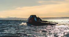
Transitioning to climate-friendly, flexible and resilient transportation takes a significant leap with the commencement of the new research project Autoflex. This initiative aims to introduce small, autonomous zero-emission inland vessels,...
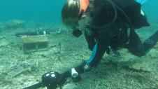
Researchers at the Heron Island Research Station in Australia are using a Nortek velocimeter to determine how much hydrodynamic energy it takes to move “coral rubble”, the skeletons of corals...
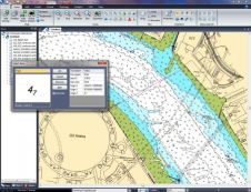
Cadcorp is a British software development company focused on geographic information systems (GIS) and web mapping software. From its headquarters in Stevenage, UK, Cadcorp is growing both its direct and...
The 1st Conference on Spatial Statistics 2011: Mapping Global Change is to be held from 23rd to 25th March 2011 at the University of Twente, Enschede, The Netherlands. Spatial statistics...
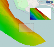
The latest release of Spatial Fusion Enterprise builds on its support of Open Geospatial Consortium (OGC) standards by implementing the Web Coverage Service (WCS) standard for bathymetric data. The new...
CARIS has released Spatial Fusion Enterprise (SFE) version 5.3 featuring the new Web Map Tile Service (WMTS). SFE allows an organisation to deliver its geospatial information to the Web using...
This site uses cookies. By continuing to use this website, you agree to our Cookies Policy. Agree