An automated and reliable solution for the generalization of nautical charts
March 20, 2023
Cartographers working in hydrographic offices and ENC editors have the responsibility of processing bathymetry datasets to generate ENCs compliant with the S-57 IHO standard. This is a time-consuming and fastidious task that requires a specific set of skills and knowledge. Nowadays, this expertise is challenged by the constant progress being made in data acquisition techniques and equipment, which has led to a significant increase in the number and size of bathymetry datasets. To face these challenges, the CARTONAUT project was launched by Shom cartographers in collaboration with GEOMOD marine geomatics engineers, both located in Brest, France. The project led to the creation of CALHYPSO, an automated solution for the generalization of bathymetry datasets for S-57 ENC production. This article reports the development of CALHYPSO through the CARTONAUT project and provides details about the tool’s concept and features.
The generalization process: a safety imperative
In hydrographic offices, as in all ENC editing organizations, cartographers oversee the processing of bathymetry datasets from which the information displayed on S-57 ENCs is based. Using the input datasets, cartographers estimate the seabed configuration and generate the corresponding features describing the seabed in alignment with the S-57 standard. In doing so, they apply a reliable simplification of the information displayed on the marine chart – a process called generalization. The safety of mariners depends on the reliability and accuracy of the ENCs generated in this process, which is why cartographers attach great importance to performing valid generalization. This task is precise, time-consuming and requires specific knowledge about navigation.
The boom in bathymetric data acquisition: a growing challenge
There has been significant progress in data acquisition strategies and instrumentation in recent decades. These improvements have induced an important step forward in the precision of bathymetry surveys, resulting in larger datasets. The number of sources from which reliable bathymetry datasets can be extracted is also increasing. It is therefore a challenge for data processors to keep up with the complexity of this data, and cartographers need to maintain the specificities of their expertise in the application of the generalization process while dealing with the increased data density. In other words, data acquisition and data processing need to keep up with the technological improvements.
CARTONAUT project: an ambitious and collaborative work
Considering these observations, Shom decided in 2020 to work jointly with GEOMOD to enhance cartographic operations through an ambitious automatization project called CARTONAUT. The main focus was to provide a software solution that achieves fast and reliable sounding selection and generalization. This solution was required to process the high-density (multibeam, Lidar) bathymetry datasets efficiently, perform a reliable and automated generalization process and offer a customized solution that was designed based entirely on cartographers’ practices.
CALHYPSO: a Chart Assistant soLution for HYdrographic Processing and Simplification Operations
Two years after the launch of CARTONAUT, the first version of the CALHYPSO software was released in October 2022. CALHYPSO’s main feature focuses on processing input bathymetry datasets to generate S-57 ENCs. The CALHYPSO package includes three tools:
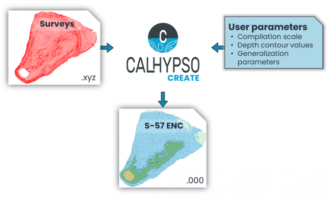
Create: Produce S-57 ENCs from input bathymetry datasets
Control: Highlight potential security uncertainties in the produced S-57 ENCs
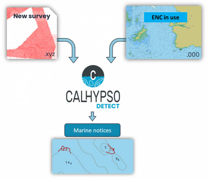
Detect: Compare an in-use ENC and an up-to-date bathymetry dataset to detect seabed evolutions threatening navigational safety
It is assumed that the input dataset has been acquired in accordance with the IHO Standards for Hydrographic Surveys S-44, and the main input is a homogeneous-density XYZ point cloud saved in .lgz, .glz, .txt, .csv, .xyz, .asc, .dat or .pts format. Users can define the required compilation scale and depth contour values, and the software generates the S-57 ENC output including bathymetric features such as depth contours, depth areas and soundings.
A more detailed output ENC can be obtained using additional inputs. Optional environmental features such as land areas, dredged areas, underwater rocks and wrecks and obstructions can be loaded in the software in input ENC (.000) format and the bathymetry generalization is adjusted to these objects.
Figure 1 -> Overview of the main feature CALHYPSO-create.
CALHYPSO: the main steps of the generalization algorithm
The steps covered by the software follow the manual process performed by cartographers. These are described below.
Decimation and triangulation
The first step aims to reduce the amount of data to make the generalization process as fast as possible. To this end, and in a complete security approach, shallower soundings are saved and triangulated until the resolution is compatible with the scale specified. Thus, multibeam echosounder and bathymetric Lidar datasets can be reduced by a factor of ten on average.
Morphological analysis
The triangulation is analysed to extract morphological features such as peaks, crest lines, passes, thalwegs and hollows. These specific soundings then make up the sounding selection.
Isoline extraction and simplification
Isoline segments are extracted from triangulation and simplification operations are successively applied to aggregate nearby isolines and obtain simpler polylines.
Sounding selection and isoline exaggeration
Final soundings to be written on the chart are selected following depth-distance generalization rules. As a consequence, surroundings of these soundings are exaggerated. In fact, to avoid any superposition between soundings’ text and the isoline curve, nearby isolines are pushed offshore, ensuring both readability and navigation safety.
Unsymmetrical smoothing
To facilitate map reading, smoothing is applied to polylines to obtain nice-looking curves. This smoothing is unsymmetrical because the isoline is systematically pushed offshore.
S-57 features creation
Finally, the isolines are converted into standard depth contours and depth area S-57 objects. CALHYPSO-Create exports the resulting S-57 dataset composed of bathymetric S-57 objects but also land areas, dredged areas or dangers if they are input as an option.
Control and Detect: additional tools for navigational safety
Additional tools are supplied to assist cartographers in quality control (CALHYPSO-Control) and the update of ENC charts (CALHYPSO-Detect). CALHYPSO-Control aims to ensure a complete security control. The cartographer can compare the initial bathymetry datasets and the produced ENC to identify and check any uncertainties. In fact, where the algorithm applies a rule, the cartographer evaluates several configurations and defines the most suitable one based on their expertise and knowledge of mariners’ habits.
CALHYPSO-Detect focuses on updating the current chart catalogue with new survey datasets. The tool determines which ENC intersects the dataset and identifies new dangers that could constitute critical marine notices. Hydrographers can then quickly analyse discrepancies and alert mariners.
Figure 2 -> Overview of the additional feature CALHYPSO-detect.
Conclusion
CALHYPSO is a software package dedicated to cartographers and ENC editors. The tool aims to facilitate ENC edition for cartographers, allowing them to focus on other tasks for which their expertise is required. The tool was born from a trusted partnership between Shom cartographers and GEOMOD marine geomatics engineers.
CALHYPSO-Create has three main benefits: (1) it allows cartographers to triple their productivity by reducing the time spent on bathymetry (Shom cartographers estimate that a 15 days of edition work is reduced to five minutes); (2) the generalization rate can be adjusted by the cartographer to match the generalization practices of the hydrographic agency; and (3) the tool guarantees reproducibility and uniformity of the produced charts by reducing the amount of human intervention in the process and uncertainty.
Download PDF or Print
Download this article as a print friendly PDF and receive our weekly overview of the most important geomatics news and insightful articles and case studies.
Sharing this article
Ofcourse we encourage you to share this article with your peers if you enjoyed reading it. Copy the URL below or share it on your social media of choice.
This site uses cookies. By continuing to use this website, you agree to our Cookies Policy. Agree