
Rijkswaterstaat, part of the Dutch Ministry of Infrastructure and Water Management, is responsible for managing and maintaining the main infrastructure facilities in the Netherlands. As part of its efforts to ensure the safety and functionality of the Waal/Upper Rhine waterways, Rijkswaterstaat initiated a project to perform hydrographic measurements. These measurements are essential for assessing the condition of the infrastructure networks, determining maintenance requirements and ensuring the accessibility and navigability of the waterways. The consortium of Baggerbedrijf de Boer B.V. and Aquifer Consultancy B.V. was entrusted with the execution and management of the project. They were responsible for conducting regular hydrographic measurements at three locations along the Waal dams near Wamel, Dreumel and Ophemert. Additionally, measurements were carried out at the sediment replenishment site in the Boven-Rijn near Tolkamer.
The challenge
The project’s primary objectives were to assess the condition of the infrastructure networks, determine the need for maintenance and ensure the safety and navigability of the waterways. To achieve these objectives, various measurements were conducted using advanced hydrographic techniques.
The solution
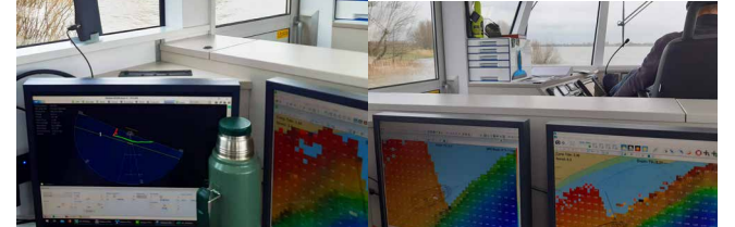
The hydrographic measurements along the Waal dams involved using the Teledyne SeaBat T-Series multibeam system, enabling high-resolution bathymetric riverbed mapping. The multibeam measurements provided detailed information about the depth and contours of the river channel, allowing for accurate assessments of navigability and potential risks. In addition to multibeam measurements, stream gauge measurements were performed using the Teledyne SeaBat T-Series system. These measurements assessed the vertical profiles of water properties, such as turbidity and suspended sediment concentrations, which are crucial for understanding sediment transport and erosion patterns. Current measurements were also conducted to gather data on flow velocities and directions, providing insights into the dynamics of the waterway and potential navigational challenges.
Measurements at the sediment replenishment site were then required. In the Boven-Rijn, the focus was on monitoring the deposition of controlled gravel on the riverbed. The measurements included multibeam bathymetric surveys to assess the effectiveness of the replenishment process. Depending on water levels, stream gauge measurements were performed periodically to analyse sediment transport and suspended sediment concentrations. Current measurements were also carried out to understand the flow patterns and dynamics in the area.
The advantages
Utilization of the Teledyne SeaBat T-Series multibeam system offers clients several advantages:
- High-resolution bathymetric mapping: the SeaBat system provided accurate and detailed mapping of the riverbed, enabling precise assessments of depth, contours and potential navigational hazards.
- Efficient data collection: the system made it possible to cover large areas in a relatively short period. This efficiency was crucial for conducting regular measurements at multiple locations.
- Comprehensive water property analysis: the combination of multibeam and stream gauge measurements facilitated a comprehensive analysis of water properties, including turbidity, sediment concentrations and suspended sediment transport.
Enhanced safety and navigation: the accurate hydrographic data obtained using the SeaBat system supported informed decision-making regarding infrastructure maintenance, ensuring the safety and navigability of the waterways.
Conclusion
The implementation of the Teledyne SeaBat T-Series system played a vital role in the successful execution of the Rijkswaterstaat hydrographic measurements project. The system’s high-resolution bathymetric mapping capabilities, coupled with stream gauge and current measurements, enabled comprehensive assessments of the waterways’ condition and facilitated informed decision-making regarding maintenance requirements. By leveraging advanced hydrographic techniques, Rijkswaterstaat can continue to ensure the safety, accessibility and functionality of the Waal/Upper Rhine waterways for years to come.