TCarta Develops AI-based Commercial Bathymetric Mapping Technologies
TCarta Marine has announced the development of new machine learning-based bathymetric mapping technologies – including the creation of two software packages and the commercial application of NASA’s ICESat-2 satellite – with funding from the National Science Foundation (NSF).
“The NSF grant has brought value to the bathymetric mapping arena in many ways,” said TCarta president Kyle Goodrich. “We have applied the newly developed satellite-derived bathymetric (SDB) mapping techniques in numerous commercial and government projects worldwide.”
The commercial bathymetric mapping projects relate to oil spill management, oil & gas exploration and production, coastal infrastructure engineering, environmental monitoring and geospatial intelligence activities. Customers include private sector organizations as well as numerous international government agencies.
As TCarta begins the second year of its NSF Phase II grant, the company has announced the release of two bathymetric software products developed through the programme:
Multispectral Bathymetric Tool for Esri ArcPro – a toolbox within the popular Esri GIS software to process satellite-derived bathymetry data, assess accuracy, and output as .BAG files.
ICESat Data Extraction Software – a tool that leverages artificial intelligence algorithms to automatically extract seafloor depth measurements from ICESat-2 laser data.
Shallow-water Seafloor Depths
In 2018, NSF awarded TCarta a Phase 1 grant to develop multi-method and integrated SDB technologies. Referred to as Project Trident, the research focused on leveraging artificial intelligence (AI) – machine learning and computer vision – to determine shallow-water seafloor depths in variable water conditions. The two-year Phase 2 grant focused on commercialization of these technologies and was awarded in late 2019.
“An exciting addition to Project Trident was NASA’s ICESat-2 satellite data, which we incorporated into the workflow as a validation tool and algorithm training for the enhanced SDB technologies currently under development,” said Goodrich. “TCarta became the first to integrate the ICESat-2 laser measurements into commercial bathymetric projects and now routinely offer these enhancements.”
Polar Ice Elevation and Tree Canopy Measurements
Developed by NASA and the University of Texas, ICESat-2 (Ice, Cloud & land Elevation Satellite) was designed primarily for polar ice elevation and tree canopy measurements, but the green laser altimeter onboard has proved remarkably accurate at gauging seafloor depths down to 100 feet below the surface.
By combining the ML-based SDB techniques with the ICESat-2 validation methods, TCarta developed an entirely new workflow for deriving highly accurate water depth measurements at scale from multiple high-resolution satellite images for large coastal areas. In the past year, TCarta has deployed this technique in high-profile projects, which are described below.
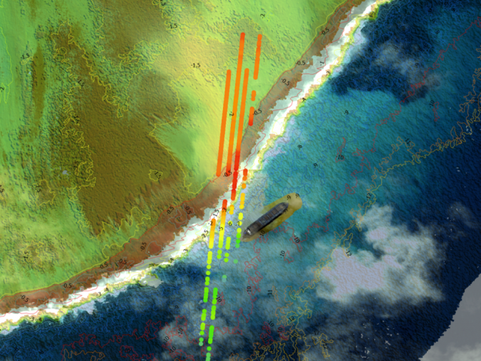
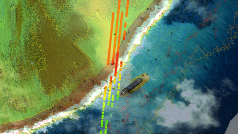
WV Wakashio grounding and oil spill: In the immediate aftermath of the Indian Ocean shipwreck off the coast of Mauritius, TCarta acquired Maxar WorldView-2 satellite imagery over the poorly charted area and applied the new ICESat-validated SDB method to map the sea floor. The bathymetric data sets were published via web mapping service and made freely available through Esri’s ArcGIS Online and Maxar’s SecureWatch platforms.
Hurricane Dorian Response and Isaias Threat: Demonstrating the ability to scale up the SDB method to include a multitude of images, TCarta applied the technology to process over 400 Sentinel-2 satellite images over the Bahamas region from post-hurricane Dorian imagery and validated with millions of ICESat-2 data points. The result was a 10-metre bathymetric map covering 130,000 square kilometres provided via the Esri Caribbean GeoPortal to organizations engaged in hurricane preparedness activities ahead of Hurricane Isaias.


