120-year maritime mystery of lost steamship unravelled
A 120-year-old mystery has been solved with the help of a CSIRO team aboard the RV Investigator. Heritage NSW has announced the discovery of the SS Nemesis, a 73-metre iron-hulled steamship that vanished at sea in 1904. The uncharted wreck was located by marine survey company Subsea Professional Marine Services and reported to Heritage NSW in May 2022. The SS Nemesis was on a voyage from the Australian city of Newcastle to Melbourne, transporting coal, when it vanished in a storm off the coast of New South Wales, resulting in the tragic loss of all 32 lives on board.
Subsea Professional Marine Services located the wreck during an underwater survey off Wollongong, NSW, and undertook an initial inspection of the site using a remotely operated vehicle. CSIRO, Australia’s national science agency, was petitioned by Heritage NSW to investigate the wreck to gather further data to aid in its identification.
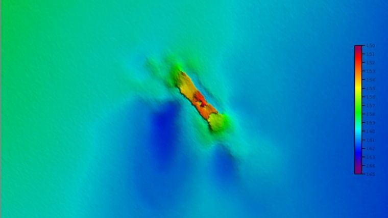
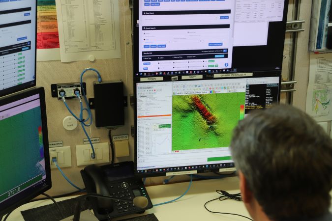
RV Investigator was able to conduct a detailed seafloor mapping and camera investigation of the wreck while on a transit voyage from Hobart to Sydney in September 2023. The CSIRO team used the vessel’s advanced multibeam echosounders to first map the wreck site and surrounding seafloor in high resolution. They then conducted a systematic visual inspection of the entire wreck using a specialized underwater drop camera system.
Capturing incredible imagery
CSIRO voyage manager Jason Fazey said RV Investigator was in the right place at the right time to assist Heritage NSW and conduct the survey: “Our voyage track took us right past the wreck and we were extremely lucky with the conditions for the survey, with our team onboard doing a superb job in capturing incredible imagery of the wreck. We surveyed the entire length of the wreck with our drop camera, revealing a lot of detail of the ship’s structures including some of the internal spaces.”
Phil Vandenbossche, a CSIRO hydrographic surveyor on board the voyage, said the seafloor mapping by RV Investigator shows the wreck is lying in 160 metres of water and is approximately 28 kilometres off the coast of Wollongong, NSW. “The wreck is located towards the edge of the continental shelf and is sitting upright on the seafloor but is showing significant damage and deterioration at both the bow and stern. Our visual inspection of the wreck using the drop camera showed some key structures were still intact and identifiable, including two of the ship’s anchors lying on the seafloor,” he explained.
The bathymetry and camera survey data from RV Investigator, along with the previous imagery collected by Subsea, allowed Heritage NSW’s maritime archaeology experts to identify the wreck as the SS Nemesis.
Highly collaborative effort
Senior maritime archaeologist with Heritage NSW Dr Brad Duncan said that the SS Nemesis was originally a passenger vessel but was converted and operating as a coal carrier when it disappeared. “On its final voyage in July 1904, SS Nemesis left Newcastle for Melbourne with its hold full of coal and cokes. However, shortly after departure, the vessel ran into a southerly gale and was subsequently lost at sea off the NSW coast with the tragic loss of 32 lives on board.”
Dr Duncan said that like many wreck discoveries, locating the SS Nemesis was the result of a highly collaborative effort between research and heritage agencies and the maritime community. “The wreck is one of many thousands of shipwrecks that lie along the Australian coastline, with many still to be found.”
“This discovery and confirmation of the wreck’s identity not only provides significant archaeological information about the ship and wrecking event but, more importantly, may offer some solace to the families and friends of those who perished onboard as it provides a location at which they can mourn their loved ones,” Duncan added.
The video imagery collected by RV Investigator will now be ‘stitched together’ to create a 3D photogrammetric model of the wreck to allow it to be investigated in further detail.
Jason Fazey said CSIRO is honoured to be able to assist the maritime heritage community in identifying and protecting this significant shipwreck: “We hope this helps bring some closure to another of our nation’s maritime mysteries.”
The wreck of the SS Nemesis is protected as a historic shipwreck under the Underwater Cultural Heritage Act 2018. The project was supported by an allocation of sea time on RV Investigator by the CSIRO Marine National Facility, national research infrastructure that is supported by the Australian government’s National Collaborative Research Infrastructure Strategy (NCRIS) and operated by CSIRO, Australia’s national science agency, on behalf of the nation.


