Analysis of CZMIL and Coastal Mapping Technology
A current user of the Teledyne Optech CZMIL Coastal Zone Mapping and Imaging Lidar will make a presentation , comparing various Lidar bathymeters during Shallow Survey 2015, to be held at Plymouth University, UK, from 14-18 September.
The presentation ‘A look into the performance of bathymetric Lidar systems’ given by Chris Macon of the Joint Airborne Lidar Bathymetry Technical Center of Expertise (JALBTCX) is scheduled at 10:15 on Wednesday, 16 September. JALBTCX spent the summer testing several types of bathymetric Lidar sensors and Mr. Macon will discuss their results.
Depth up to 65m
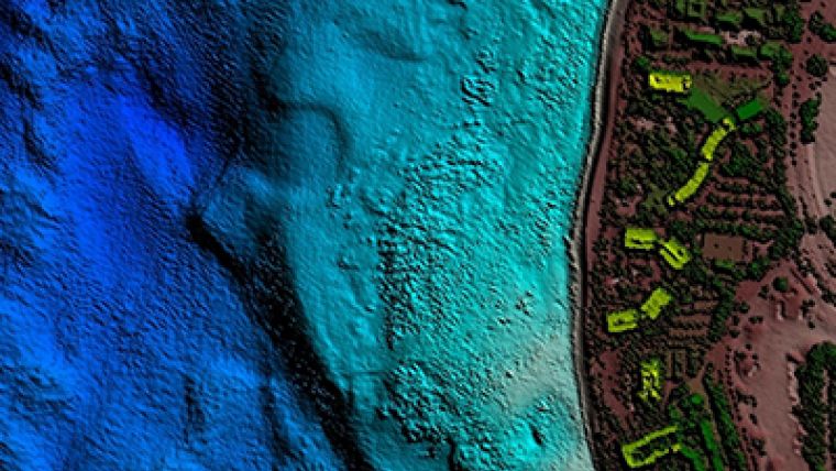
The Teledyne Optech booth M14 will have examples of bathymetry work from CZMIL in turbid water in Asia and Lake Michigan, where HydroFusion’s Turbid Water Module vastly improved bottom detection even in locations with inflowing rivers. In the clearer conditions around Hawaii, JALBTCX performed a production survey of over 1,500km of coastline with CZMIL, ranging from 300m inland to 1,000m offshore in waters up to 65m deep. Visitors can learn more about these surveys at the Teledyne Optech booth with technical experts from our bathymetry team, who will discuss how CZMIL’s depth penetration varies with water quality.
With the conference focusing on high-resolution surveys in shallow waters, Teledyne Optech expects CZMIL Nova to gain a great deal of attention for its ability to detect objects as small as 1m3 in water up to 25m deep. CZMIL Nova has also expanded the list of coastlines that can be surveyed with Lidar, thanks to advanced electronics and data processing techniques that let it survey regions with waters too turbid for other Lidars to penetrate. This bathymetric surveying solution is now available even to smaller agencies, which can borrow the system for short surveys through the CZMIL Project Programme and install its newly redesigned hardware into small twin-engine aircraft.
Shallow Water and Terrestrial Mapping
The Optech Titan is also an industry focus due to its innovative multispectral Lidar technology, which enables shallow-water bathymetry, high-density topography/environmental mapping, and vegetative analyses in a triple-wavelength configuration.
Coastal management authorities can learn about how the Optech ILRIS-MC terrestrial Lidar recently helped survey Sydney Harbour in partnership with a multi-beam echosounder. This innovative watercraft-mounted solution is proving a rapid and inexpensive way to survey critical sections of shoreline in extreme detail both above and below the waterline.
Image: CZMIL surveyed the coast of Hawaii up to 1km offshore at depths down to 65m. Image courtesy: JALBTCX.


