Challenges of Mapping Small Hydroelectric Dams
By the end of 2008 ‘small-hydro' dams were generating over 85 gigawatts of power from installations with capacities of a few hundred kW up to a few tens of MW (compared to the Hoover dam at over 2000MW). These installations often use existing dams or are developed alongside new dams whose primary purpose is river water-level control or irrigation. There are many thousands of these small dams worldwide (over 95,000 in the USA alone) and maintaining this infrastructure requires accurate mapping and monitoring. This presents some challenges to the hydrographic surveyor. Here, the experiences of one company providing hydrographic surveys of dams in the Apennine mountains of Italy are described.
In 2007 Pangea Srl was contracted by Enel SPA to perform bathymetric and topographic surveys around hydroelectric plants located in the Lazio and Abruzzo regions of central Italy, including installations on rivers such as the Liri (province of Frosinone) and the Tiber (upstream of Rome). The project covered many sites but each individual survey project was fairly limited in area, including some dams only a few tens of meters across.
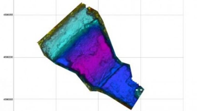
The accuracy requirements for monitoring the sedimentation and shape of a dam floor are comparable to a ship navigation channel or dredge works. Knowledge of the water depth and total volume is required for dam maintenance and to maximise the renewable energy output. Detailed bathymetry allows improved irrigation planning and flood control, and survey images show the status of the dam infrastructure (such as the threshold and sluice gates). Accurate depth maps can also can be critical to the safe operation of the hydroelectric facility and inform the risk assessment of the dam structure.
The difficulties posed by this kind of survey are in two main areas. First, the difficulty of mobilisation of survey assets caused by the remoteness of the survey site, limited access to the banks and the lack of piers. The dam may be some distance from the nearest road, requiring all the equipment to be carried over rough land. Second, running the survey lines is difficult because of the limited depth of water (sometimes less than a meter over much of the dam periphery) along with the presence of hazards to navigation such as trees or submerged structures. Often during the survey the boat will need to navigate close to a shore covered by dense vegetation and around the hydroelectric plant structures. These difficulties exclude the possibility of using a standard survey launch; something much lighter and man-launchable is required, but it still has to carry a fully capable hydrographic survey rig.
For this contract Pangea chose two vessels: a 3.7m long aluminium boat and a 4.30m inflatable boat. The advantages of the aluminium boat is its lightness and strength; it is easily transportable, is straightforward to launch and robust around obstacles. However it was found to be fairly unstable especially when loaded with crew and numerous instruments that raised the centre of gravity. The advantage of the inflatable boat was the stability, allowing good mobility when the boat was fully loaded and operating. However it was heavier and less resilient, leading to transport difficulties where waterside access was limited and the greater likelihood of damage during launching or around obstacles. In order to limit the weight and the quantity of equipment to be carried to the site a small 2HP outboard engine was often used (or even oars in the smallest sites). In the larger surveys and in the rivers a 15HP outboard engine was used.
Choice of a suitable integrated hydrographic package was key to successful completion of the contracts. The requirements were for wide swath bathymetric mapping to better than IHO special order specifications along with co-registered side-scan images for structure inspection, with reasonable productivity in water depths often less than 1m and data collection up to the waterline. The GeoSwath Plus (GS+) interferometric sonar from GeoAcoustics Ltd (a Kongsberg Maritime Company) was chosen. One of the great advantages of the GS+ for this type of small boat work is its compactness. Most of the ancillary sensors are integrated into the transducer V-Plate which saves space, saves time during installation and allows pre-calibration of the offsets between the sensors. Full calibration on-site would often have been difficult because of the small extent of the survey areas. Another advantage of the GeoSwath is the robustness of the V-Plate and transducers; more than once an accidental grounding left the system undamaged.
The equipment sometimes had to be hand carried over rough terrain to the waterside, which is only feasible for a compact system like the GeoSwath Plus. The boat was separately craned in or manhandled to the water. At each survey site the transit to the waterside, installation of equipment on the vessel and system tests took about 2 hours in total. Data acquisition usually lasted 1-2 hours (sometimes much less on the smaller dams), and dismantling took about 1 hour. The biggest problem usually encountered was how to get the equipment from the van to the waterside and back.
The data deliverables were bathymetry and side scan data processed by GS+ as well as depth profiles exported directly from the real-time data collection windows. The real-time side scan data displays also proved to be very useful for data interpretation on-site. The images accompanying this article show a few of the installations used and bathymetric survey results. After carrying out successful survey seasons in 2008 and '09 Pangea can report that the compact GeoSwath Plus is ideal for this type of small boat hydrography in harsh environments.
This project has shown that modern highly accurate wide swath hydrographic survey equipment can be economically deployed for restricted area surveys, with rapid mobilisation and limited time on-site. Even the smallest hydropower dam can be fully mapped quickly and efficiently. This type of mapping capability can be used to increase the safety and efficient operation of small-hydro projects worldwide.


