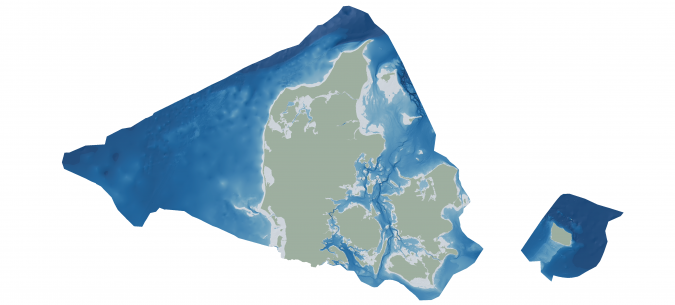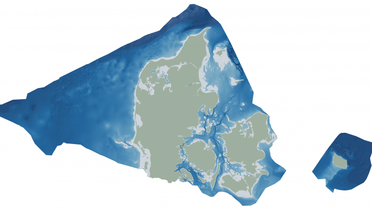
Danish Geodata Agency and EOMAP unite to map Denmark’s shallows
Through the collaborative implementation of satellite-derived bathymetry (SDB), the Danish Geodata Agency and EOMAP are synergizing efforts to contribute to the European Marine Observation and Data Network (EMODnet) Bathymetry partnership. Their shared goal is to seamlessly integrate SDB data into the Danish Depth Model (DDM).
Harnessing cutting-edge satellite technology, this partnership aims to enhance the precision of mapping shallow-water areas currently lacking comprehensive bathymetric coverage. This initiative is poised to play a crucial role in expanding the coverage of the DDM, a sophisticated mapping framework developed by the Danish Hydrographic Office, an integral component of the Danish Geodata Agency.
Seamless shallow-water grid
“Finding new ways to map shallow waters, where we only have very old data, and increasing the utilization of depth data for marine stakeholders and society are central to the goals of the Danish Hydrographic Office. Satellite technology shows great potential in this regard. We are therefore happy to contribute to this cooperation that benefits the users of both the DDM and EMODnet Bathymetry,” said Elizabeth Hagemann, head of office in the Danish Hydrographic Office.
“Denmark is particularly rich in shallow waters, with considerable parts mapped more than 100 years ago. For filling data gaps in large areas, SDB is widely approved as a very efficient technology. Together with existing bathymetric data, this cooperation project will thus help create a seamless shallow-water grid of the Danish coastline and its hundreds of islands,” stated Knut Hartmann, COO of EOMAP.
As an additional benefit for marine stakeholders, the project will also be embedded in the large-scale European model by EMODnet Bathymetry. “EMODnet Bathymetry provides the harmonized bathymetric surface for all European waters. We foster new ideas and concepts which aim to provide better mapping of our waters. Therefore, we very much appreciate this cooperation and believe that the Danish grid – integrated into the next EMODnet Bathymetry release – will contribute to improving the accuracy of our product and will fulfil the expectations of our users,” explained Thierry Schmitt, coordinator EMODnet Bathymetry.