EIVA Releases Upgrade of Survey Data Software Solutions
EIVA’s software combination, NaviEdit and NaviModel, has undergone a significant upgrade. NaviEdit is the company’s software tool for editing survey data, while NaviModel enables the creation of high-performance digital terrain models in 2D and 3D. These two tools go hand in hand, working together across the various NaviSuite software bundles, such as NaviSuite Kuda for hydrographic surveys and NaviSuite Nardoa for pipeline inspections.
In these recent updates, EIVA has made a variety of improvements based on the experiences of users of previous versions. The following sections discuss some of the handy new software features, including faster 3D object rendering, new data cleaning and modelling tools, running on cloud services and supporting bin grid data.
Automated Sonar Data Cleaning Turns Democratic
NaviModel features the automatic 3D data cleaning tool EC-3D. This tool has been upgraded in NaviModel 4.5; EIVA has added a new data cleaning method, made it possible to use multiple data cleaning methods at once, and redesigned the user interface for a more intuitive user experience.
Rather than assuming one method will always work perfectly, with EC-3D hydrographers can use a variety of methods to identify noise in the data. In the latest version, these data cleaning methods can be used simultaneously and combined in different ways, and the settings can be customized. To do this, the user first needs to select the data cleaning methods to use. In the new user interface, it is possible to click through the different methods in one window, and to use the slider tool to adjust the bounds for each data cleaning method.
Relative vs. Absolute
For each method, the user can choose to clean data in a relative or absolute manner. The relative manner is based on ‘votes’ of the different cleaning methods. For example, the user can specify that a point must be marked as noise by at least two methods before it is removed. The absolute manner is, on the other hand, a ‘dictatorship’. A method using the absolute manner will always clean a point it considers noise, regardless of how it is marked by any of the other cleaning methods.
The relative manner is a customizable democracy, since users can adjust how many votes it requires – meaning how many methods must mark a point as noise before it is removed. When viewing the results of relative data cleaning, the number of votes can be edited using a slider, and the result is shown right away, so it is intuitive and easy to find the right setting.
Once the data cleaning set-up has been designed, it can be saved and loaded into a new project. This is particularly useful if the same kind of data needs to be cleaned multiple times, as it will usually benefit from the same data cleaning set-up.
Fast 3D Rendering for Full Visualization
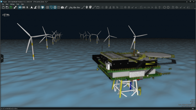
While NaviModel has long been known for its powerful modelling of digital terrains, this latest update addresses the current trend, which is that more and more customers are using NaviModel not just to process data, but to visualize the environment too – full geographic information system (GIS) visualization.
To make NaviModel an even more powerful tool for visualization, the 3D model rendering has been made faster and more efficient. The files supported by NaviModel have also been expanded to include a wide variety of file formats for 2D CAD drawings, 3D drawings and mesh files.
In NaviModel 4.5, 3D rendering has been optimized by eliminating unnecessary uses of resources. One way in which this is achieved is by only drawing what is inside the NaviModel view screen. In addition, the level of detail drawn is dependent on how far the user zooms in. These may sound like minor issues, but the result of this optimization speaks for itself. In NaviModel 4.5, 3D objects are rendered much faster, making it possible to handle larger models than in previous versions and to render several 3D drawings simultaneously, while reducing the load on the graphics card.
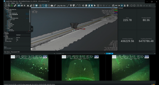
In addition to improving the rendering of objects in NaviModel, version 4.5 features several new and improved tools. These include 3D coverage display, on-screen measurements, the ability to set a filter for DTM (digital terrain model) import, smooth video replay with overlays, and a web viewer.
Subsea Software Headed for the Cloud
During this Covid-19 pandemic, so many people were working from home that the decision was made to try out NaviEdit and NaviModel on cloud services. There are many benefits to working in the cloud: server hardware and general IR maintenance is outsourced, the server size is easily scalable based on day-to-day needs, and automatic backups can be generated.
Together with Deep Ocean Group, tests of NaviEdit and NaviModel were run in the cloud on two cloud platforms: Amazon web services and Azure. The test showed that running NaviEdit and NaviModel in the cloud was as fast and sometimes faster than a local computer connected to an SQL server, although not as fast as running on a local PC with good hardware.
With the testing complete, the new versions of NaviEdit and NaviModel are ready to be used in the cloud. This will be discussed in a future EIVA LIVE webinar about a more direct way of using NaviSuite in the cloud. So, stay tuned by following the EIVA cruise.
New in NaviSuite: Bin Grid Data
The new versions of NaviModel and NaviEdit allow for the import and quality control (QC) of P6/11 seismic bin grid data. Various parsing and consistency checks are performed by the importer in NaviEdit and can be evaluated in the report. NaviModel can import the bin grid data from NaviEdit for visual QC. This includes inspection of the NaviEdit report, the perimeter and individual bin nodes. The axis and orientation can be evaluated along with general BinGrid information in the Info View.