Exploring submarine canyon shaping through innovative MBARI techniques
Cutting-edge technology has been utilized to survey Monterey Canyon’s seafloor by a research team comprising members from MBARI, USGS, Durham University, the University of Hull and Pontificia Universidad Católica de Chile. By conducting repeated surveys, they gained fresh insights into the processes shaping the canyon.
The team harnessed advanced MBARI technology to meticulously map portions of Monterey Canyon, providing essential context not only for understanding seafloor life but also for assessing the vulnerability of underwater infrastructure to potential landslides. Monica Wolfson-Schwehr, who led the study, stressed the significance of comprehending canyon-forming processes.
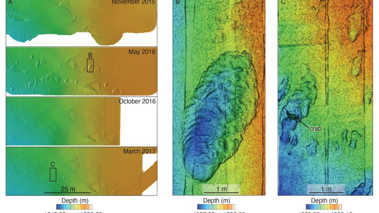
During the Coordinated Canyon Experiment spanning 2015 to 2017, researchers employed the Low-Altitude Survey System (LASS) to delve into the canyon’s evolutionary mechanisms. Crafted by MBARI’s Seafloor Mapping Lab, LASS combined multibeam sonar, Lidar and stereo photography to deliver highly detailed seafloor visualizations.
Sonar and Lidar to map seafloor characteristics
Operational on a remotely operated vehicle (ROV), LASS employed sonar and lasers to capture intricate seafloor characteristics and three-dimensional objects. Merging detailed photographs with bathymetry data enabled the precise quantification of seafloor modifications brought about by geological, geochemical and biological processes. The research team carried out numerous centimetre-scale surveys at a site approximately 50 kilometres from the canyon’s origin, achieving an unparalleled level of resolution in submarine canyon research.
“MBARI’s Low-Altitude Survey System maps seafloor environments at the scale of the animals that live there, making it particularly useful for ecological studies. In this geological project, the Lidar bathymetry data revealed changing centimetre-scale textures in the sediment on the floor of Monterey Canyon that would have been undetectable by more traditional methods like ship-based sonar or even the autonomous mapping robots we use to map at one-metre scale,” explained MBARI principal engineer Dave Caress. “Even though MBARI scientists and engineers have been exploring Monterey Canyon for more than 25 years, our new technology is constantly revealing surprises.”

Pairing repeated surveys of the canyon floor with water current monitoring and sediment sampling provided researchers with a more complete picture of activity in Monterey Canyon.
As part of the Coordinated Canyon Experiment, the team deployed a Seafloor Instrument Node (SIN) on the floor of Monterey Canyon. Upward-looking acoustic Doppler current profilers on this instrument recorded the currents flowing along the canyon.
Swift turbidity currents transport sediments and organic carbon through submarine canyons, draping the floor with sediment and altering its features. These currents can also damage seafloor infrastructure such as cables and pipelines. Studying these currents is challenging due to their unpredictability.
Between 2015 and 2017, SIN sensors recorded three turbidity currents moving at 0.9 to 3.3 metres per second. Despite their speed, LASS surveys indicated minimal changes to the canyon floor, possibly due to coarser sediment and large boulders. Tides also impact submarine canyons. SIN sensors tracked daily tides, revealing subtle sediment shifts aided by MBARI’s LASS technology.
Bridging the gap
The study discovered that tides shaped small features on the canyon floor, previously missed due to resolution limitations. This research showcases how advanced mapping tools can bridge the gap between modern seafloor surveys and understanding ancient geological records.
“With sonar, we see the aftermath of large, catastrophic events, but miss the small, minute changes that happen every day,” said Wolfson-Schwehr. “As technology advances and we can map at finer and finer resolutions, we can observe a new level of complexity in the seabed. We don’t realize how much of the picture we’ve been missing.”
“Geology has always been a historical science that looks at seafloor deposits laid down a long time ago. MBARI technology is allowing us to study submarine geomorphology at a scale we haven’t been able to before. Repeated high-resolution surveys are providing a real-time dimension for understanding seafloor changes,” added Charlie Paull, a senior scientist at MBARI and a coauthor of this study.
MBARI’s Seafloor Mapping Lab has used the LASS sensor suite to map a variety of other seafloor features and habitats at centimetre scale, including methane gas seeps, faults, deep-sea coral and sponge communities, octopus nurseries and hydrothermal vents.
“We can’t understand global change to the ocean floor without quantifying it,” said Paull. “Repeated use of MBARI’s Low-Altitude Survey System allows us to collect unique quantitative data that put into perspective exactly how big these changes are. We now have a new window into how the world operates.”
MBARI is continuing to develop and improve its seafloor mapping capability. Building on the success of the LASS, MBARI is collaborating with 3D at Depth to develop a next-generation underwater Lidar system that can be integrated into autonomous platforms and enable further progress in efforts to map the deep ocean floor in the future.
The findings of the research team have been published in JGR Earth Surface.


