Investigating the world’s largest undersea waterfall in the Atlantic Ocean
University of Barcelona leads oceanographic expedition
The University of Barcelona is leading an expedition to investigate the world’s largest waterfall, which is actually located underwater between Iceland and Greenland. Although the physical oceanography has been extensively studied, this research is aimed at exploring unknown aspects such as sediment transportation, relief modification and topographic influence. Deep-sea information will be gathered for a whole year, until September 2024.
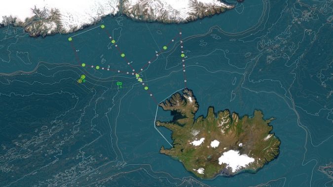
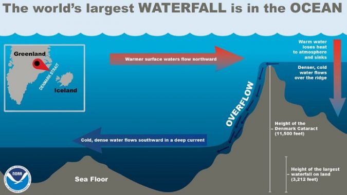
The largest waterfall in the world is located in the Denmark Strait between Iceland and Greenland. More than three kilometres high, it has a flow of cold, dense water that exceeds three million cubic metres per second. This gigantic current is generated in the Arctic, where surface water cools, gains density, sinks and makes its way to lower latitudes, following the topography of the seabed. The submarine relief of the Denmark Strait – which goes from 500m to more than 3,000m deep in the space of a few kilometres – causes this bottom current to accelerate and overflow in the form of an underwater waterfall until it reaches the great troughs of the northern Atlantic Ocean.
This phenomenon plays a decisive role in the Atlantic thermohaline circulation – and therefore in the global climate – and is key to the functioning of the deep-sea ecosystems in the area. Although this dense water overflow has been intensively studied by the scientific community from the point of view of physical oceanography, there are key aspects that are still unknown. These are now being addressed in the FAR-DWO oceanographic campaign, which was carried out from 19 July to 12 August 2023 aboard the oceanographic ship Sarmiento de Gamboa (owned by the Spanish National Research Council). The project is being led by Professor David Amblàs and Professor Anna Sanchez-Vidal, both from the Consolidated Research Group on Marine Geosciences of the Faculty of Earth Sciences at the University of Barcelona (GRCGM-UB), Spain.
Unknown aspects: sediment transportation, relief modification and topographic influence
The professors explain that, while the hydrodynamic characteristics of this large underwater cataract have been studied in the past, FAR-DWO is aimed at exploring aspects that are as yet unknown. “Such as its capacity to transport sediments and modify the relief and the influence of topography on its propagation”, say David Amblàs and Anna Sanchez-Vidal, members of the Department of Earth and Ocean Dynamics (part of the Faculty of Earth Sciences) at the University of Barcelona. “FAR-DWO will analyse for the first time the hydrographic and sedimentological variability from the sampling and observation of the water column and the sediment and relief of the seafloor during the campaign. We have deployed two instrumented lines at great depth that will record current information for a whole year, until September 2024, when they will be recovered.”
Pioneering work in northern Catalonia
Undersea waterfalls are one of the most fascinating phenomena in modern oceanography. Their impacts on the seafloor were unknown until they were first described off the northern coast of Catalonia, in the northwestern Mediterranean, in a scientific paper led by GRCGM-UB researchers (Nature, 2006). Since that study, GRCGM-UB has been a pioneer in research – with lines instrumented with sediment traps, current meters and temperature sensors – to monitor dense water cascades both in the Cap de Creus canyon and in various polar areas.
The phenomenon of dense water overflow is particularly intense in the Arctic and Antarctic. “The poles are the regions where most of the dense water masses – generated by the formation of sea ice at the surface – eventually reach the global ocean floor. The polar areas are like the heart of the oceanic circulatory system: they pump cold, dense water into the great oceanic troughs through the ‘heartbeats’ made by overflows of dense water,” states Amblàs.
The effects of climate change on undersea waterfalls
There is increasing evidence of the effects of global change on the phenomenon of undersea waterfalls. “A good example is on the Catalan coast, where the decrease in the number of tramontane days in winter in the Gulf of Lion and north of the Catalan coast is causing a weakening of this oceanographic process, which is decisive in regulating the climate and has a great impact on deep ecosystems,” says Sanchez-Vidal.
In polar areas, a greater influx of freshwater and less sea-ice formation will also mean a reduction in the volume of dense water moving towards lower latitudes. “This process has several effects on global ocean circulation that are of concern to the scientific community, as reflected in the latest report by the Intergovernmental Panel on Climate Change (IPCC),” continues Sanchez-Vidal.
The aim of the researchers during the FAR-DWO campaign is to take the knowledge about the behaviour of undersea waterfalls and the impacts they generate one step further. “For this reason, we will intensify and expand the monitoring efforts performed so far in the Cap de Creus canyon, combining the results with the monitoring of the waterfall in the Denmark Strait,” they comment. “These two study areas – one temperate and the other polar – provide an ideal frame of reference to investigate the propagation of these currents, the associated biogeochemical fluxes and their imprint on the seafloor and sedimentary record, as both marine areas are major players in the global ocean thermohaline circulation system,” they add.
Reconstructing the evolution of oceanographic processes
“Observational data from both marine areas will be combined with a numerical hydrosedimentary model, which will provide for the first time a quantification of the ability of marine cascades to shape the seafloor,” the professors explain. “The FAR-DWO project will also analyse the cascade variability in response to current and past climate changes. Through historical observations, reviews of oceanic and atmospheric models, and sedimentological and geochemical indicators in marine sediment cores, it will be possible to reconstruct the evolution of these oceanographic processes under different past climate scenarios.”
The FAR-DWO campaign involves approximately 30 experts from the University of Barcelona, the Institute of Oceanography and Global Change (IOCAG) of the University of Las Palmas de Gran Canaria, Center of Training and Research of the Marine Environment (CEFREM) of the University of Perpignan, the French Research Institute for the Exploitation of the Sea (IFREMER), the University of Iceland, and Lobelia Earth, a company specializing in satellite technology. In addition, FAR-DWO is supported by the Marine Technology Unit (UTM-CSIC).