Mapping rivers and lakes with an autonomous watercraft
Surveying bodies of water accurately is a challenging task, while authorities and port operators are required to provide up-to-date maps of riverbeds and port facilities. Until now, this has required the use of special mapping vessels and a great deal of manpower. This is costly and is not being carried out with the frequency and precision that will be required for future applications, such as autonomous shipping. For this reason, a team of researchers at the Fraunhofer Institute of Optronics, System Technologies and Image Exploitation (IOSB) has developed an easy-to-operate, uncrewed watercraft that autonomously surveys bodies of water such as rivers, lakes and harbours both above and below the surface and produces corresponding 3D maps.
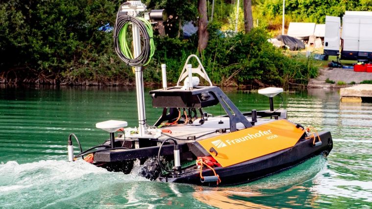
Watercourse maps provide important information, for example about the depth of the watercourse, the soil and bank conditions, the bed structure, the longitudinal and transverse profiles, the embankment, adjacent parcels of land, port facilities, bridge structures, the condition of the watercourse and much more. These maps need to be compiled and updated regularly by the relevant authorities, which is very costly as the surveys are currently carried out manually with the help of specialists on mapping vessels. It is far less expensive to carry out underwater and surface mapping using autonomous watercraft. Researchers at Fraunhofer IOSB in Karlsruhe have developed such a system as part of the TAPS project (German-language acronym for ‘semi-automatic navigation system for rivers and lakes’) based on a commercial unmanned surface vessel (USV). Connected only to a central workstation or control station on land, the survey vessel maps all types of inland waters and their surroundings, surveying both above and below the water surface. Coastal applications are also feasible, since in its current form the system can map depths of up to 100 metres.
High-precision 3D models of above-water and underwater scenery
Using its GPS, acceleration and angular rate sensors, as well as a Doppler velocity log (DVL) sensor that enables the boat to incrementally feel its way along the bottom of the body of water, the vessel can move autonomously. The data from the various sensors is merged to guide the semi-automatic navigation system. For mapping above water, laser scanners and cameras are used in combination with mapping software developed at Fraunhofer IOSB, enabling the devices to reconstruct high-precision 3D models of the surroundings. The underwater mapping, in turn, is carried out with the help of a multibeam sonar, which is integrated into the sensor system and creates a complete 3D model of the bed. “Our navigation system is semi-automatic in that the user only needs to specify the area to be mapped. The surveying process itself is fully automatic, and data evaluation is carried out with just a few clicks. We developed the software modules required for mapping and autonomous piloting ourselves,” explained Janko Petereit, scientist at Fraunhofer IOSB.
USV bypasses obstacles autonomously
The first step is to specify the area to be surveyed. The software then uses this information to calculate the route. Next, the USV, which measures 2 metres x 1.5 metres x 1 metre and is very light at 64 kilograms, starts up. While fulfilling its task, it autonomously evades obstacles detected by the laser scanner and sonar. During the journey, a quick 3D model is generated in real time for navigation purposes, including of dynamic objects such as moving vessels. A second high-precision 3D model is computed by the software after data evaluation, capturing both the floor of the body of water and the scene above the water surface, while also hiding moving objects.
The tests of the surveying vessel took place on several different lakes. The operational prototype is currently being used by the Fraunhofer research group Smart Ocean Technologies in Rostock in other projects that focus on underwater and surface robotics.

Software enables autonomous navigation on open water
There is a wide variety of potential applications for the developed technology. Besides autonomous surveying of navigation channels and civil engineering structures, autonomous excavation of waterways is also conceivable. Users simply wanting to navigate bodies of water autonomously without mapping them can also make use of the software stack developed in the project. For this reason, Petereit believes that there will ultimately be opportunities for deployment and further development in all areas of passenger and freight transport on the high seas and on inland waters. “We will see a massive increase in autonomous shipping on German waterways in the future, culminating in new types of logistics chains that intelligently combine rail, road and water transport.”
In addition to autonomy algorithms, autonomous shipping also requires highly accurate maps, which are not always available at present, as Petereit points out: “Currently, manual surveys are only conducted every one or two years and provide far less accurate results than our comprehensive 3D models, so the condition of the waterways is not optimally captured. River surveys will therefore need to be conducted much more often in the future and with a higher level of detail. Our semi-automatic navigation system offers a cost-effective alternative to current surveying methods.”


