New Project Aims to Demonstrate Autonomous Monitoring on a Wider Scale
Voyis has announced the development of the IMAGE (Image Mapping & Analysis for Governance and Education) project, funded through Fisheries and Oceans Canada’s Ocean Management Contribution Programme (OMCP).
This project will bring together strong industry partners: Voyis, Cellula Robotics and Shift Environmental Technologies. Together, these organizations will conduct autonomous underwater vehicle (AUV)-based image mapping and interpretation of Canadian Marine Protected Areas (MPAs) to efficiently monitor, manage and educate in ocean management.
The OMCP provides funding opportunities to eligible applicants to support marine conservation initiatives with an emphasis on outreach, monitoring and stewardship, as well as capacity-building initiatives.
Four Main Project Goals
Marine researchers increasingly rely on remote video and images from underwater vehicles to monitor marine habitats such as coral reefs, boulder fields and kelp forests. With new high-resolution 3D data, high-speed imaging and machine learning approaches, there is an opportunity to automate MPA surveys and use this data automatically by classifying and counting the abundance of various species over time.
Yearly data sets can be consistently collected and compared to infer environmental and population changes, possibly caused by climate change, pollution or other external factors.
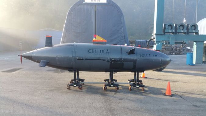
This project seeks to demonstrate that the Canadian ocean management sector can apply this autonomous monitoring approach on a wider scale. This objective can be accomplished by developing a robust commercial solution with Cellula’s Solus-LR AUV fitted with Voyis optical sensors, in addition to demonstrating surveys with local indigenous stakeholders who could become the future stewards of an MPA monitoring strategy.
The project has four main goals:
- Goal 1 – Monitoring Solution Development: Design and integration of Voyis optical sensors into the Solus-LR to build an MPA monitoring and interpretation solution.
- Goal 2 – Indigenous Training & Mission Planning: Engage and build the Indigenous community's technical ability to participate in marine environmental monitoring and ocean conservation planning.
- Goal 3 – Survey & Analysis: Execution of survey operations and data analysis following developed mission plans.
- Goal 4 – Governance & Education: Dissemination of collected data to improve education and inform new methodology and site establishment.
Improving the Localization of Seabed Features
Voyis will supply a laser scanning and imaging package for integration into Cellula’s Solus-LR AUV to complete the first goal. Using Voyis’ stills camera and LED panel, the project will improve researchers’ abilities to monitor large areas of seafloor with high-resolution images and laser data with new automated image interpretation software. This high-resolution technology, combined with the new image interpretation software, will improve the localization of seabed features for future data comparisons using optical navigational aiding algorithms.
Solus-LR is a hydrogen fuel cell-powered AUV with a submerged range of over 2,000km. Solus-LR was developed by Cellula for Defence Research Development Canada under the Arctic All Domain Situational Awareness programme. Cellula will integrate the Voyis camera system and plan and execute the MPA survey missions.
To achieve the second project goal, Shift Environmental Technologies will leverage its existing First Nations relationships to facilitate training of the indigenous community on AUV survey operations and gain input on selecting survey locations.
With the first two goals completed, the third goal and completion of the survey and data analysis can be achieved, which will rely on all project partners working together.
For the fourth outlined goal, an educational organization will join the consortium to build on its world-leading contributions to monitor remote MPAs. Along with Fisheries and Oceans Canada, it will use the high-resolution wide-area data sets collected in the project to drive improvements in ocean education programmes, governance and monitoring methodologies.