New seabed maps uncover secrets below the surface
More than 1,500 individual seabed surveys have been combined to give sectors such as marine park management and offshore renewable industries – as well as storm surge modellers – a more comprehensive snapshot of what lies at the bottom of our oceans. Led by Geoscience Australia in collaboration with its partners James Cook University, the Australian Hydrographic Office and the University of Sydney, this project represents decades of data acquisition.
“Our oceans offer increasing opportunities for economic growth, with emerging ocean industries including the offshore renewable energy sector generating new job opportunities and contributing to Australia’s future economic prosperity,” Dr Jodie Smith, head of the Oceans, Reefs, Coasts and the Antarctic branch at Geoscience Australia, said. “This only happens with a comprehensive picture of the seabed. Because this compilation provides a national dataset and shows in greater detail the transition between land and sea, its applications extend across a wide range of industries, including tourism, fishing, aquaculture, renewable energy, defence, search and rescue, marine research, environmental protection and marine infrastructure.”
Smith continued: “Mapping and study of the seabed is essential to inform decisions on the sustainable use of our oceans and to drive our nation’s progress towards a prosperous and environmentally sustainable future.”
Unified chart of Australia’s maritime domain
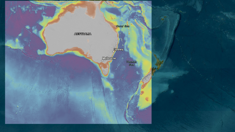
To coincide with the compilation’s launch, Geoscience Australia has produced a national seabed map and released a 3D fly-through of the South Australian, Tasmanian, Victorian, New South Wales and Queensland coasts, showing detail of the transition between land and sea, the shelf and offshore canyons.
“The compilation allows Australia’s marine estate to be shown on a single seamless map at 250-metre resolution,” Dr Smith said. “We can see features at a national scale, allowing us to step back and take an informed, big-picture view of Australia in its marine context.”
Smith continued: “Knowledge of the depth and shape of the seabed is fundamental for building ocean circulation and climate models, while also serving as a vital tool for assessing underwater hazards, sediment transport and environmental changes.”
Dr Smith said it was also a critical resource for coastal management, supporting blue carbon initiatives – that is, carbon captured by the world’s ocean and coastal ecosystems – and improving inundation, storm surge and erosion modelling. “There is a wealth of resources to be found under the surface of our oceans, but timely, evidence-based decision-making about the sustainable use of our marine jurisdiction relies on accurate data.”
While this compilation was focused primarily on improving the coastal transition between land and sea, Geoscience Australia will continue to add higher resolution datasets in high priority areas in future versions, such as shallow depths more suitable for renewable energy development.
The new national data compilation is publicly available through the AusSeabed data portal.


