NOAA explores California’s marine frontiers with advanced technology
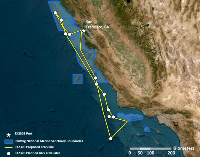
From 21 October to 11 November, NOAA Ocean Exploration is leading expeditions aboard the NOAA Ship Okeanos Explorer off the coast of central California and within the boundaries of the proposed Chumash Heritage National Marine Sanctuary. The primary objective of this expedition is to test the operation of autonomous underwater vehicles (AUVs) while gaining deeper insights into the biology and geology of the proposed sanctuary.
In its commitment to expedite ocean exploration, NOAA Ocean Exploration is collaborating with the NOAA Ocean Exploration Cooperative Institute (OECI) to put two AUVs to the test during this venture. This testing initiative serves three vital purposes. First, it aids in understanding how the AUVs can be seamlessly integrated into and enhance the standard operations of the Okeanos Explorer, enabling the collection of high-resolution seabed and water column mapping data. Second, it facilitates the collection of baseline data to support critical scientific and management requirements in nationally significant areas. Third, it helps identify the optimal sites for remote-operated vehicle dives during future expeditions.
Upgraded seabed and water column mapping technologies
Both AUVs, known as Eagle Ray and Mola Mola, are owned and operated by the University of Southern Mississippi, an affiliate of OECI, and have recently undergone updates featuring the latest mapping and imaging technologies. Eagle Ray, a traditional mapping AUV, is equipped with multibeam sonar and a sub-bottom profiler, enabling it to capture high-resolution seabed and water column mapping data. Mola Mola, a photo survey AUV, is equipped with a powerful camera and laser system for seabed imagery and additional mapping data.
In addition to these technological advancements, NOAA Ocean Exploration is collaborating with NOAA’s Office of National Marine Conservation, Channel Islands National Marine Sanctuary, and local tribal members to identify exploration targets. The organization is also playing an integral role in educating local tribal communities about deep-sea exploration and promoting the proposed Chumash Heritage National Marine Sanctuary.