S-101 – The new IHO Electronic Navigational Chart Product Specification
S-101 is the new product specification for Electronic Navigational Chart (ENC) datasets based on the overarching S-100 framework standard of the International Hydrographic Organisation (IHO). The development of S-101 is being coordinated under the IHO’s Transfer Standard Maintenance and Applications Development Working Group (TSMAD). In the future, S-101 compliant ENCs will succeed and ultimately replace S-57 compliant ENCs as official chart data for ECDIS.
The development of S-101 reflects the experience of stakeholder feedback with regard to the current limitations of S-57 based ENCs. The ultimate goal is that an S-101 ENC will provide the base chart layer for S-100 integrated products and the underpinning of e-navigation. Its full potential will be realised as other types of products used within the maritime domain, such as aids to navigation, vessel traffic services, oceanography and meteorology, etc., adopt the concept and develop interoperable products and services modelled along the S-100 framework as well.
S-101 – How is it Different from S-57?
S-101 compliant ENCs are not a radical reengineering of the S-57 concept. S-101 retains most of the characteristics that are currently used in S-57 ENCs, but also improves those elements of S-57 that benefit from the flexible framework, which has been established under S-100 and aligned with the current ISO 19100 series of geospatial standards. While S-101 encompasses a variety of new elements, this article will only cover a select few.
Machine Readable Catalogues
The biggest advantage that S-101 has over the existing S-57 ENC product specification is the introduction of dynamic feature and portrayal catalogues. The term dynamic is used to indicate the possibility of adapting them when required. While similar in content to the current S-57 object catalogue and S-52 presentation library, S-101 implements the dynamic constructs prescribed by S-100. Under the current S-57 ENC regime updates of such elements may take up to five years to implement through the development and implementation of ECDIS software updates because the catalogues are embedded in the ECDIS software. In S-101, the relationship between features, attributes and enumerants are defined within a single feature catalogue. The elements of the portrayal catalogues link the feature catalogue elements to their graphical representation. Although, part of the standard, the feature and the portrayal catalogues are built through a registry responsible for defining dataset elements and are machine readable. Under S-100 the content of the registry is continuously adapted, but the S-101 feature and portrayal catalogues will be versioned, enabling the IHO to take advantage of the dynamic register content. In addition to the feature and portrayal catalogues, S-101 will also provide another catalogue containing the official IHO producer codes and – as a new element - a catalogue defining alerts and indications for use in the ECDIS. The advantage of moving to a fully machine readable catalogue system is that the ECDIS will be able to update new elements via a catalogue update which comes together with a regular data delivery. This ‘plug and play’ mechanism will be much simpler to implement by both manufacturers and end users than the current process which requires prolonged software updates.
Complex Attributes
S-101 will also make use of a new S-100 feature to enhance the encoding, transfer and portrayal of data called a complex attribute. A complex attribute is an aggregation of other attributes, either simple or complex and is similar to the ISO 19000 attribute of attribute.
Complex attributes are a significant improvement to enhance S-101 applicability. It provides the ability to either replace multiple attributes or break down attributes into new sub-attributes.
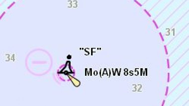
For example, the existing S-57 attribute OBJNAM (name of the feature) is remodelled into a complex attribute. This is done to better control the display of the feature name on the ECDIS. It now includes two sub-attributes called ‘displayName’ and ’name’. The sub-attribute ‘displayName’ is defined as a Boolean and when toggled in the data it indicates that this is the name to be displayed on the screen. By having the feature name as a complex attribute, it allows producers to store multiple names of the same feature. So instead of the ECDIS showing ‘San Francisco Approach Lighted Whistle Buoy ’SF’’ (Figure 1) the ECDIS will only display the ‘SF’ (Figure 2) and the full name of the buoy will be discoverable via the pick report.
Update Feature
One of the biggest problems users have with S-57 data is ascertaining what changes have been made after an update has been applied to the data. In this case, the ECDIS does not have enough information to properly depict or highlight what are commonly important changes. The main problem is that in order to update a simple feature in S-57, it may affect underlying geometry that is also transmitted as part of the update. This results in unrelated information depicted in the highlight update routine that the ECDIS performs. In order to streamline this function and enable users to clearly see what changes have been applied to a dataset via a notice to mariners, including any features that have been deleted, S-101 has introduced the update feature carrying this meta information. The update feature will enable the ENC producer to clearly indicate what has been updated and if necessary the source of that update – such as a notice to mariners. For example, this will be particularly useful for detecting changes that may affect a route chosen during passage planning.
Text Placement
Another new feature that has been introduced in S-101 is the cartographic feature type. This new feature type, and its associated attributes, will enable S-100 based ECDIS to have better control over the way text is positioned on the display. Gaining individual control about the positioning of text will improve the overall look and feel of ENCs in ECDIS. For example, instead of description of channel buoy lights appearing across a channel area (Figure 3), it will be possible to move them away from the channel area (Figure 4).
Production System Attributes
Currently, an S-57 based ECDIS has to spend considerable time during loading to identify the relationships between the geometries of certain features e.g. a wreck and its surrounding depth area. This is done in order for the System ENC (SENC) to pre-determine the appropriate display criteria so that the system can execute the S-52 Conditional Symbology Procedures (CSP) correctly. In order to reduce the need to call up these complex procedures that need to be calculated by the ECDIS at any change of the presentation, the ENC production systems will pre-calculate the values describing this relationship; store them as an attribute of the feature and export it as part of the S-101 dataset. This will increase the efficiency of creating the SENC, reduce the need for a significant number of CSPs and contribute to a faster and simpler loading process.
S-101 Test Bed
Before the IHO Member States can approve S-101 as a functional standard, it must undergo a rigorous testing process that will require the implementation of test bed projects. It is important to understand that this test bed will need to be S-100 based, capable of testing other product specifications which can be either supplementary to S-101 ENCs or non-related GIS applications. The overarching test bed strategy is depicted in the following Figure which shows the logical progression from catalogue creation to use within an ECDIS.
However, in order to manage the complexity of the testing process it has been divided into nine phases that cover the entire end-to-end process as depicted in the following diagram.
Breaking out the testing through phases allows for the iterative development of future ECDIS as a system by gradually expanding requirements and the different types of test scenarios that are needed to validate S-101 as a functional standard.
The outcome of testing will also enable a more detailed impact study, as prescribed by IHO Resolution 2/2007 on principles and procedures for making changes to IHO technical standards and specifications, and will provide a clear picture of the effects on the various stakeholders involved in the eventual introduction of S-101.
Conclusion
Developing S-101 requires the support from both the IHO Member States, ENC production software companies and ECDIS manufacturers. Even though the test bed is in the early phases, the introduction of S-101 and S-100 based ECDIS systems will result in greater interoperability between different navigational products such as high-resolution bathymetry, surface currents and weather overlays. It will introduce greater flexibility in updating mechanisms and improve the display of electronic navigational charts for an improved user experience.
Acknowledgements
Thanks are due to Barrie Greenslade, Mathias Jonas and Gilles Bessero.


