Seapath 385 launch marks milestone for Kongsberg Discovery
Kongsberg Discovery commemorates 30 years of inertial navigation excellence with the launch of Seapath 385. Unveiled at Oceanology International in London, this innovative system integrates new hardware and advanced navigation algorithms, promising optimal precision for hydrographic surveying. The GNSS-aided INS underscores Kongsberg Discovery’s commitment to advancing marine navigation technology.
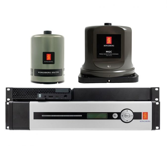
Seapath 385 combines state-of-the-art inertial technology and processing algorithms with multi-frequency GPS, GLONASS, Galileo, Beidou, QZSS and geostationary satellite signals. The system integrates raw inertial sensor data either from Kongsberg Discovery’s high-performance MGC (motion gyro compass) or MRU (motion reference unit), together with GNSS data and RTK, PPP or DGNSS corrections.
The result is an integrated, robust and highly accurate solution that delivers unique performance every time, according to Vidar Bjørkedal, vice president sales at Kongsberg Discovery. Since 1994, Seapath has set the benchmark for excellence in hydrographic surveys across the entire ocean, he noted. The 385 pushes the bar higher than ever before.
By uniting data from an array of critical sources, integrating Kongsberg Discovery’s market-leading inertial navigation technology and then enhancing both the hardware – boosting processing power and upgrading interfaces – and refining algorithms, Kongsberg Discovery has taken a new evolutionary step in this demanding technology niche.
Centimetre position accuracy
For surveyors demanding the ultimate in precision, the benefits of the 385 range are compelling. Thanks to the system’s inertial sensor and updated navigation algorithms, dead reckoning performance is second to none. Another layer of robustness is added by the innovative utilization of GNSS antennas for both positioning and heading determination.
A new post-processing format contains all necessary data and system configuration in a single file, with the possibility of achieving centimetre position accuracy through downloaded satellite orbit and clock data or data logged from base stations.
The modular system, with a processing unit running all critical computations independent from the user interface on the HMI unit, offers easy installation and continuous, reliable operation. Measurements are highly precise, with a data rate of up to 200Hz at multiple monitoring points, easily accommodating sensors or systems relying on motion or position data across the vessel.
Building on a legacy
“For hydrographic surveying where high-precision heading, position, velocity, roll, pitch, heave and timing are critical, Seapath 385 stands alone,” Bjørkedal said. “By building on the legacy of operational and technological expertise that we’ve acquired over the last 30 years we can position ourselves to continually meet customer demand and solve challenges with this kind of breakthrough solution.
“It’s an exciting step forward, giving the market the means to facilitate next-level seabed mapping for the most challenging applications and environments. It’ll be fascinating to see what results it achieves.”