Second seafloor survey completed at California coastal dumpsite
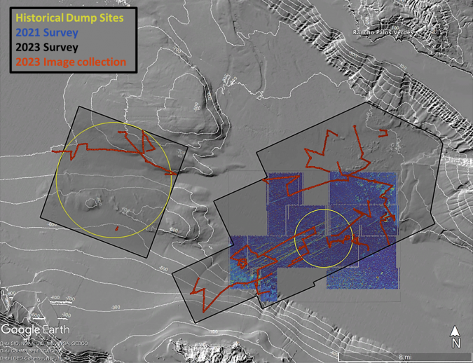
In a second seafloor survey off the Southern California coast, researchers from UC San Diego’s Scripps Institution of Oceanography uncovered a staggering 350 square kilometres of discarded military munitions. The April 2023 exploration, part of ongoing efforts to fathom the environmental consequences of industrial waste dumping, sheds light on the underwater landscape’s intricate tapestry.
Led by Scripps oceanographers Sophia Merrifield and Eric Terrill, the 2023 survey used a deep-water autonomous underwater vehicle (AUV) with state-of-the-art synthetic aperture sonar and a remotely operated vehicle (ROV) with an HD video camera, both capable of working up to full ocean depth of 6,000 metres. The expedition took place with support from the US Navy’s Supervisor of Salvage and Diving and the Office of Naval Research.
Between the 1930s and 1970s, the site was a known location for industrial dumping, including of by-products from the manufacturing of the pesticide DDT, and was initially surveyed using robotic vehicles by the same team in April 2021. The goal of the second survey was to extend maps of the seafloor using higher resolution acoustic sonar imaging techniques, to apply video imaging systems to classify objects in a previously mapped debris field, and to collect observations of deep-sea ocean currents. The 2023 survey mapped 350 square kilometres and recorded more than 300 hours of video footage.
Disposal practices
The 2021 survey, published in Environmental Science and Technology, documented thousands of barrel-sized objects organized in lines across the basin. Imagery collected in 2023 along debris lines found the majority of the objects to be multiple types of discarded military munitions and pyrotechnics. Barrels from the legacy of industrial dumping and several old fishing vessels were also found. The barrels were found to be concentrated in two locations, and were not pervasive across the dump site.
“The resolution of the sonar provided by the US Navy Supervisor of Salvage provides us with an unprecedented map of the seabed which will take some time to fully appreciate and analyse,” said Terrill.
The 2021 and 2023 survey findings have been received by the US Navy. According to a statement from the Navy: “These munitions are likely a result of World War II-era disposal practices. While disposal of munitions at sea at this location was approved at that time to ensure safe disposal when naval vessels returned to US ports, the Navy follows Department of Defense guidance for the appropriate disposal of munitions that aligns with state and federal rules and regulations.”
Risk management
The Navy will also be reviewing the findings to determine the best path forward to ensure that the risk to human health and the environment is managed appropriately and within applicable federal and state laws and regulations.
Scientists also mapped whale falls, which are sunken whale carcasses. A total of seven whale falls were confirmed with video imagery, but the sonar data suggests more than 60 may exist in the footprint of the survey data collected by the AUV.
“The number of whale falls seems quite high relative to previous models of how many may occur on the seafloor off California,” said Scripps Oceanography marine biologist Greg Rouse, who has studied the ecosystems around whale falls. “However, the skeletons were mainly in very low-oxygen water that likely slowed decomposition markedly, and the burial rate by sediment may also be very slow there. This would mean the whale falls may have accumulated over many decades.”
Read the full story at the Scripps Institution of Oceanography website