The challenges of coastal mapping and shallow-water surveying
Mapping shallow, nearshore areas can be a challenging job. The waters along coasts and islands are important to human activities, but when it comes to mapping these areas there is still a lot of work to be done. Here, we have selected five articles that provide us with inspiration, insights and food for thought when it comes to shallow-water and coastal mapping.
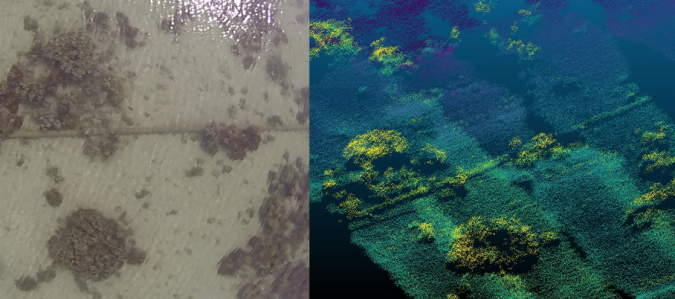
Bathymetry from UAV imagery and machine learning
Accurate bathymetric mapping of shallow areas is essential for a plethora of offshore activities. Through Structure from Motion (SfM) and Multiview Stereo (MVS) techniques, images can provide a low-cost alternative compared to Lidar and sonar systems while also offering important visual information. This article presents a new framework for mapping the seabed in clear and calm shallow waters for small- and large-scale surveys using aerial imagery and machine learning to correct the geometric effects of refraction on the 3D point clouds and the imagery. Read the full story here
Sentinel-2 coastal charting worldwide
It is widely and wrongly assumed that the world’s coastal regions have been surveyed in detail by modern techniques and that the resulting nautical charts are an accurate reflection of the nature of the seabed. This optimistic approach is not shared by the world’s hydrographic offices or the International Hydrographic Organization (IHO). Hydrographers have a saying: “The world is fully charted, it’s a shame that so little is surveyed” and, one could add looking at venerable charts, so poorly surveyed. Read the full story here
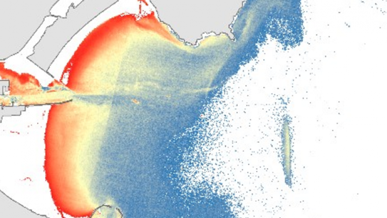
Sentinel-2 satellite-derived bathymetry in optically complex waters
Coastal areas are highly dynamic environments that are subject to diverse pressures, both anthropogenic (e.g. urban development, fishing, habitat modification) and natural (e.g. storms, erosion, floods). These pressures result in intensive and frequent seafloor alterations that demand efficient monitoring methodologies for repetitive updating of the seafloor morphology and bathymetry. Bathymetric information is essential to many coastal aspects, including environmental, management, research and economic. Read the full story here
Participatory geomatics network for coastal mapping and monitoring
Capacity-building and empowerment using low-cost geomatics equipment, easy-to-use field protocols and semi-automated processing algorithms provide a resilience pathway for coastal communities facing the effects of climate change. This article presents a participative geomatics project with the goal of increasing southern Québec’s coastal communities’ ability to map and monitor changes in their coastal environment. This co-constructed project aims to develop a participatory network of individuals and groups capable of acquiring, processing and interpreting coastal geospatial data of the Estuary and Gulf of St Lawrence (eastern Canada). Read the full story here
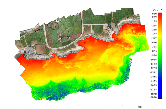
Emerging trends in bathymetric Lidar technology
A surging interest in remote sensing and analytics has seen technology developments linked to these domains take off over the past couple of years. Airborne Lidar bathymetry (ALB) is no exception to recent innovations, especially with the growing recognition of the importance of high-resolution data to inform the management of our oceans, seabed and coastal zones. In our recent discussions with ALB manufacturers and experienced operators, several significant new developments were revealed. Read the full story here