TrueOcean unveils smart hydrospatial data search tool
The TrueOcean Marine Data Platform (MDP) has recently seen the addition of a new geospatial search function that enables data on the platform to be located and accessed in seconds using a map-based interface. This major update is designed to address the challenge of searching for hydrographic survey and underwater inspection data by location.
With the acquisition of data from sensors including multibeam echosounders, sidescan sonar, magnetometers and sub-bottom profilers, a large number of individual files are created in diverse formats, which can quickly become difficult to manage and locate. Additionally, data volumes can be quite large, reaching several gigabytes, if not terabytes.
Obtaining survey datasets in seconds
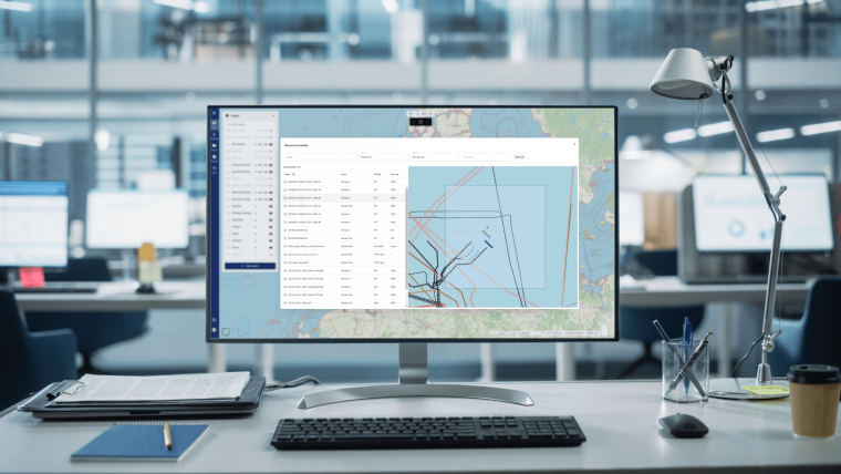
The new function simplifies searching for all hydroacoustic and geotechnical data as the operator needs only circle the corresponding area on the digital map to see a list of the available files. The platform automatically georeferences data and extracts metadata during file upload, without any user intervention, and an intelligent search algorithm works in the background to exactly match results according to input on the map.
With the hydrospatial search function, the efficiency of data management is significantly increased. Users can search for survey datasets in seconds, instead of spending days or weeks sifting through cryptic file names in deep folder hierarchies. The platform sorts the results by sensor type, file size and acquisition date, making it easy to quickly locate the desired data.
“The geospatial search function is a game-changer for marine surveyors, their clients in offshore wind and the marine engineering contractors applying the data for underwater construction,” said Jann Wendt, founder of TrueOcean. “The management of large and complex datasets has been an often laborious and time-consuming task for years, but we are confident that our new search function will increase efficiency and unlock the full potential of data on our platform.”
The TrueOcean MDP offers a range of other features to help users take control of their survey data. Users can quickly review the data before further processing, and the platform makes it easy to manage data from multiple surveys at different locations.


