Whaler Terra Nova Wreck Found
During routine functional performance testing of the mutibeam mapping echo sounders on the Schmidt Ocean Institute’s flagship R/V Falkor in July 2012, the team aboard — including researchers from the University of New Hampshire, Ifremer, and Woods Hole Oceanographic Institution — discovered the S.S. Terra Nova, a whaler, sealer and polar exploration ship that sunk offshore Greenland in September 1943 after being damaged by ice.
The performance verification of R/V Falkor’s scientific echo sounders precedes oceanographic research cruises set to begin in 2013. The tests included a shallow-water survey off the southern coast of Greenland to assess the Kongsberg EM710 multibeam mapping echo sounder’s performance in complex topography. The testing took place on July 11, 2012, as part of the planned R/V Falkor field trials during the transit of the vessel from Newcastle, UK to Nuuk, Greenland.
Researchers selected the test survey site for several reasons: It allowed testing of ship's mapping capabilities at seafloor depths between 10 and 1,800 metres and the glacial activity in the area created distinct and prominent seafloor features. Because of the glaciers, the Schmidt Ocean Institute survey team expected to see mixtures of deposits from soft sediment to gravel and boulders deposited by icebergs and glaciers. Different seabed compositions enable testing of the reception quality of the high/low back scatter signals by the multibeam system. Icebergs common to the area leave significant gouging marks on the seabed, which would effectively test bathymetric mapping data.
In addition to meeting all of these criteria for the test site, the region was also familiar to Schmidt Ocean Institute Marine Technician Leighton Rolley, who had read that the polar exploration vessel S.S. Terra Nova was reported lost off Southern Greenland in 1943. With all the topographical considerations and with the secondary possibility of using a wreck as a calibration reference for the sonar equipment, the Schmidt Ocean Institute had prioritised this location as the optimal spot for this round of tests.
Approximate estimated position of the wreck was used as the central point for the test survey. An area roughly five nautical miles around this position was selected for the survey to encompass various features, shallows and slopes necessary to evaluate the sonar performance.
The area yielded excellent topographical data that enabled comprehensive verification of the EM710 performance. The bathymetric data produced during these sonar trials was of very high quality, substantially exceeding expectations. All members of a collaborative group of sonar experts who were present on-board to evaluate the systems operational capabilities were satisfied with the outcomes of the sonar trials.
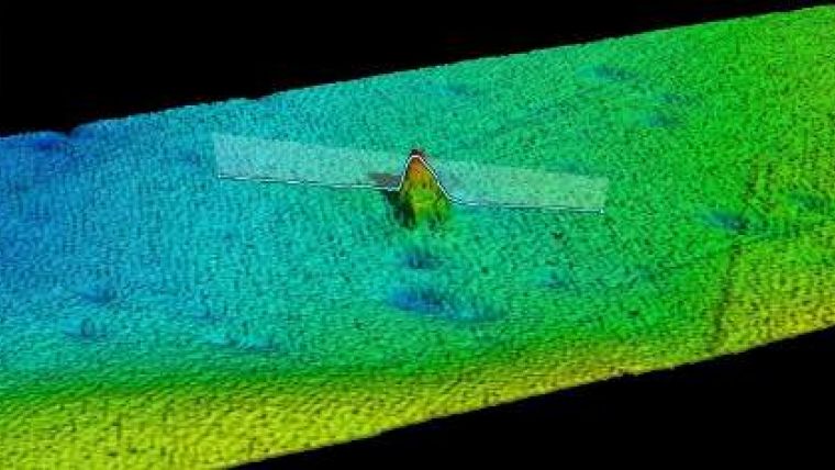
Numerous iceberg strikes and gouges were observed on the seabed along with striking features not listed on the existing nautical charts. On the first line of the calibration survey, on-board survey expert Jonathan Beaudoin from the University of New Hampshire had noted a feature on the seabed which remained initially unidentified. Upon completion of the main calibration exercise, SOI technician Leighton Rolley and Jonathan reviewed each of the many potential targets identified during the 12 hours of surveying, and the target was noted as a strong candidate for further investigation. Multibeam data expert Jean Marie from Ifremer analyzed the feature in more detail, finding its length (57m) to match the reported length of the Terra Nova. The acoustic survey team post-processed the collected multi-beam data to verify the observed feature. A shorter survey from several angles reaffirmed the possibility that the team had found a wreck.
A camera package (Simple High Resolution IMaging Package, or SHRIMP), a solid metal frame with two attached cameras and three to four dive flashlights for light, is rated to roughly 160m to match the depth of the planned plankton net tows. As the observed feature lay within the depth range of the SHRIMP, the Schmidt Ocean Institute team decided to use the camera to take a closer look.
The package dropped to a position just above the target to help identify the nature of this 57m long feature observed in the EM710 output mapping data. Camera tows across the top of the target showed the remains of a wooden wreck laying on the seabed. The camera footage also identified the funnel of the vessel, next to the wreck. The forecastle of the vessel appeared to be “peeled” upwards to the port side and at an angle from the rest of the ship. All observations jointly identified this wreck as the sunken S.S. Terra Nova.


