2D/3D Web-mapping
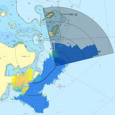
This paper describes the development of a web spatial image server used for sharing huge sets of georeferenced coastal orthophotos on the web via an easy visualisation interface. Traditional cartography...
This paper describes the development of a web spatial image server used for sharing huge sets of georeferenced coastal orthophotos on the web via an easy visualisation interface. Traditional cartography...

With innovation, progress and discovery at its heart, Oceanology International 2024 (Oi24) is preparing to welcome the world’s largest gathering of ocean professionals to the most powerful and inspirational event...
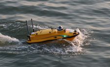
CHC Navigation (CHCNAV), a leading manufacturer of uncrewed surface vehicle (USV) technology, has introduced the Apache 3 Pro – an advanced compact hydrographic drone engineered for autonomous bathymetric surveys in...

In a March 2023 blog, Microsoft founder, billionaire entrepreneur and philanthropist Bill Gates said: “The development of AI is as fundamental as the creation of the microprocessor, the personal computer,...
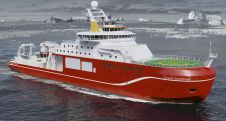
FarSounder's longest-range sonar system, FarSounder-1000, is to be the latest addition to the equipment incorporated into the British Antarctic Survey's new Polar Research Vessel: the RRS 'Sir David Attenborough'. Cammell...
Voyis, a pioneer in optical solutions for subsea vehicles, has announced its work with Memorial University of Newfoundland on an extraordinary scientific expedition to the Galápagos Islands, funded by Schmidt...
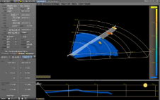
FarSounder has announced its Local History Mapping (LHM) feature, which offers users the ability to build a 3D map of the seafloor over which they have recently sailed. This map...
FarSounder, USA, has entered into an integration partnership with Wärtsilä SAM Electronics. 3D sonar data from FarSounder’s navigation systems can now be visualised and controlled directly from all NACOS MULTIPILOT...
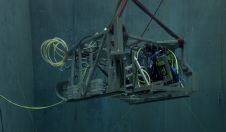
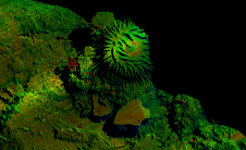
In a bid to uncover the secrets of the deep seafloor, the Monterey Bay Aquarium Research Institute (MBARI) has joined forces with 3D at Depth, a leading expert in commercial...
This site uses cookies. By continuing to use this website, you agree to our Cookies Policy. Agree