Measuring and 3D mapping of sea ice in the Arctic
How can AUVs be reliably used to map the 3D structure of the underside of sea ice, especially now that the climate crisis makes it more important than ever to...
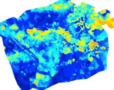
How can AUVs be reliably used to map the 3D structure of the underside of sea ice, especially now that the climate crisis makes it more important than ever to...

Precision Hydrographic Services (PHS) has recently been contracted by the Australian Hydrographic Office (AHO) to undertake a hydrographic survey in Beagle Gulf, located in the Northern Territory of Australia, to...

Governments and oceanographic institutes all around the world have recalled nearly all of their oceanographic research vessels to home port due to COVID-19, and the impact on the ability to...

High-resolution bathymetric surveys support aquaculture research and increase navigational safety. In a case study, Tim Webster reports how this is done at Cape John Peninsula in Canada. In a second...
Newly developed 3D imaging technology has allowed scientists to map Darwin Mounds, a unique area of cold-water coral reefs off the coast of Scotland, to see whether it has recovered since being...

From hydrophones attached to buoys or autonomous vehicles to a passive acoustic monitoring system, WHOI scientists and engineers have developed innovative methods to monitor marine mammals in real time. The...
Imagine you’re a port pilot, responsible for the safe passage of a cargo ship that’s about the same size as an aircraft carrier. It’s the middle of the night, it’s...
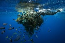
An estimated 600,000 tons of abandoned fishing gear ends up in the oceans every year. According to the United Nations, some 380,000 marine mammals are killed each year, either by ingesting this fishing gear or being caught in it. Mary T. Crowly of the Ocean Voyages Institute describes how GPS trackers are being used to mark the ghost nets. An estimated 600,000 tons of abandoned fishing gear ends up in the oceans every year. According to the United Nations, some 380,000 marine mammals are killed each year, either by...

Acquiring a better understanding of how objects drift in the ocean has importance for a wide range of uses, such as tracking algae, predicting the locations of wreckage and debris...
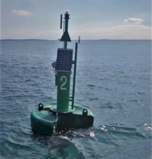
As more and more oceanographic buoys are being deployed around the world, incidents of ships striking these buoys are also increasing. At times, the impact of the strike can be...
This site uses cookies. By continuing to use this website, you agree to our Cookies Policy. Agree