Nuclear Underwater Laser Scanner
Newton Labs has developed and deployed a laser scanning product specifically designed to operate underwater, in-vessel, within either PWR or BWR reactors. The device, the NM200UW Nuclear Underwater Laser Scanner,...
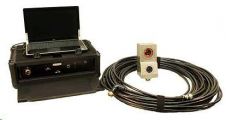
Newton Labs has developed and deployed a laser scanning product specifically designed to operate underwater, in-vessel, within either PWR or BWR reactors. The device, the NM200UW Nuclear Underwater Laser Scanner,...
In the third week of March, the entire marine world will be gathering in London, as this is where the biannual Oceanology International event is taking place. The exhibition and...
The planned widening of the Dutch Maas river (Meuse) represents a landscape correction that will prevent future flooding. Gravel barriers are being prepared in order to buffer any additional flow....

The rate of data growth is climbing exponentially, thanks to new sensors, new social networks and new ways to create and capture data. In response, Oracle is tackling four issues...
Kongsberg Mesotech, Canada, has announced the latest version of MS 1000 software for MS 1071 and MS 1171 Digital Scanning Sonar. MS 1000 Version 5.0 marks a major change in...

Southampton, in the south of the UK’s Hampshire region, will be buzzing from 9 to 11 April 2013 as hydrographic, oceanographic and offshore professionals gather for an even bigger edition...
Cadden, specialist in electronic measuring systems for geopositioning and oceanography, is entering a new growth phase. The Nantes-based small business intends to generate 20% of its sales internationally within 2...
The final piece of a CAD8.5 million research project to improve DP operations in ice fell into place on 23 May 2012 when the Government of Canada announced a contribution...
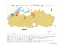
Safety of navigation on inland waterways is as important as in maritime waters. To guarantee this, Electronic Navigational Charts (ENCs) have now been produced for several years. As inland waterways...
Hydropixel is a new software company specialising in seabed visualisation and alignment chart software for the offshore survey industry with a strong emphasis on pipeline survey. We currently have two...
This site uses cookies. By continuing to use this website, you agree to our Cookies Policy. Agree