NOAA Nautical Chart PDFs Permanently Available at No Cost
After a three-month trial period, PDF versions of USA’s NOAA nautical charts will become a permanent product, at no cost to the public. The PDFs, which are digital images of...
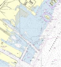
After a three-month trial period, PDF versions of USA’s NOAA nautical charts will become a permanent product, at no cost to the public. The PDFs, which are digital images of...

An IAATO sailing yacht has demonstrated that private and commercial vessels on expeditions in Antarctica can perform official hydrographic surveys and produce much-needed navigational charts for the region. Results were...
Delving into the mysteries of the planet’s final frontier – the ocean – has long captivated human curiosity, with the origins of ocean exploration dating back to 5,000 BC. But...
The United Kingdom Hydrographic Office (UKHO) has announced details of its forthcoming upgrade of the ADMIRALTY Vector Chart Service (AVCS) CD Service to S-63 Edition 1.1, the latest international open-format...

A U.S. Navy investigation to assess the circumstances surrounding the USS Guardian (MCM 5) grounding that occurred in Philippine waters will include information on faulty digital navigation chart data that...

The IHO Chart Standardization and Paper Chart Working Group (CSPCWG) has considered a proposal to advise the IHO on a suggestion put forward by the Japanese Hydrographic and Oceanographic Department,...

US Chart No.1, Nautical Chart Symbols, Abbreviations and Terms, is an essential aid for new chart users and a useful reference for all mariners. The latest version, Edition 11, is...
UKHO and JRC have announced that shipping companies fitting a JRC ECDIS now have the additional benefit of instant access to the entire range of official global Admiralty ENCs. All...

Fifteen representatives of academia, hydrographic offices and private survey companies from across Northern Europe joined CARIS and the University of Stockholm at the University on 12–16 October 2009 to learn...
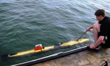
A man-portable Autonomous Underwater Vehicle (AUV) has been fitted with a wide swath sonar, capable of collecting bathymetry data for chart use. The Gavia AUV was fitted with a GeoSwath...
This site uses cookies. By continuing to use this website, you agree to our Cookies Policy. Agree