Acoustic Doppler Current Meter Workshop
Aqua Vision organises the 7th Acoustic Doppler Current Meter (ADCM) workshop in The Netherlands. This year the workshop will be organised in co-operation with the Laboratory for Physical Geography of...
Aqua Vision organises the 7th Acoustic Doppler Current Meter (ADCM) workshop in The Netherlands. This year the workshop will be organised in co-operation with the Laboratory for Physical Geography of...
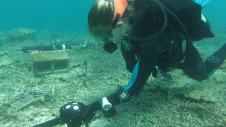
Researchers at the Heron Island Research Station in Australia are using a Nortek velocimeter to determine how much hydrodynamic energy it takes to move “coral rubble”, the skeletons of corals...
As a leading manufacturer of hydrographic and oceanographic instruments, the technology of Valeport is used for a wide variety of purposes, which includes gathering critical data about our coastal environments....
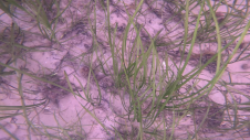
Seagrass meadows play an invaluable role as critical ecosystems that contribute significantly to marine biodiversity, carbon sequestration and coastal protection. In recent years, the importance of these underwater habitats has...
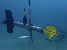
Acoustic Doppler Current Profilers (ADCPs) are sonar systems that measure water current velocities. The Doppler effect allows the sensors to measure the velocities over a range of depths, making them...

The Offshore Energy Exhibition & Conference 2023 (OEEC 2023) has concluded its two-day extravaganza, leaving an indelible mark on the offshore energy industry. Against a backdrop of innovation and collaboration,...

The rapid growth of interest in tidal energy has highlighted the role of current profilers, able to measure the speed and direction of currents with increased accuracy in some of...

USA-based Woods Hole Group has announced that it was awarded a contract to design and install a current profiling system for a subsidiary of Helix Energy Solutions Group, Inc. The...
Metocean Services International (MSI, Australia) has recently completed a deepwater current measurement programme offshore Namibia for Repsol Exploration (Namibia) (Pty) Ltd (Repsol), with 100% data return. Repsol as operator of...
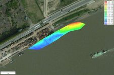
Eye4Software’s hydrographic survey package, Hydromagic version 5.1, has been released. The software maps the bottom of a river, pond or ocean in 3D by using a (D)GPS or RTK positioning...
This site uses cookies. By continuing to use this website, you agree to our Cookies Policy. Agree