LiDAR Monitoring Coastal Erosion
A new bathymetric survey of the Corsican coastline has been commissioned to provide detailed information about ongoing coastal erosion on the Mediterranean island as well as to assess the impact...
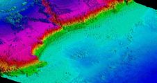
A new bathymetric survey of the Corsican coastline has been commissioned to provide detailed information about ongoing coastal erosion on the Mediterranean island as well as to assess the impact...
IVS 3D announced its partnership with Geomatics Data Solutions to provide sales, support, and training to Fledermaus clients located on the western coast of North America. With over 25 years...
The Central Dredging Association (CEDA) organises the CEDA Dredging Days on 5 and 6 November 2009 in the conference centre of Ahoy Rotterdam, in conjunction with Europort 2009. This year's...
Spatial Energy have entered into a new strategic partnership agreement with TCarta Marine LLC to exclusively offer TCarta Marine digital geospatial data and advanced GIS services globally to the energy...
The Flemish Hydrography, part of the Flemish government in Belgium, is currently setting up and integrating a Marine Spatial Data Infrastructure (MSDI) for the Belgian coast, the canal Ghent-Terneuzen and...
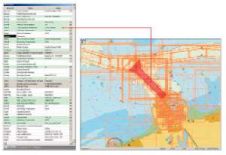
Bathy DataBASE 3.0 continues to build on its sophisticated CSAR Framework that provides support for the display and manipulation of billions of points in both 2D and 3D. The package...

The Board of the International Association of Dredging Contractors (IADC) has presented the Safety Award 2009 to DEME Environmental Contractors (DEC), the environmental specialist company of the DEME Group, for...

CEDA Dredging Days 2011, held from 9th to 11th November 2011 in the Ahoy conference centre in Rotterdam, The Netherlands, highlighted the emergence of a new trend. With its central...
In order to meet the requirements of the European Water Framework Directive (EU-WFD), authorities face the problem of performing area-wide surveys of all kinds of inland waters repeatedly. Especially for...

An international research team from Woods Hole Oceanographic Institute, USA, is reporting the results of a research cruise it organised to study the amount, spread and impacts of radiation released...
This site uses cookies. By continuing to use this website, you agree to our Cookies Policy. Agree