'As it Is'
The Military Survey Department of the Armed Forces is the sole federal mapping agency and entity in the United Arab Emirates (UAE). It is responsible for co-ordinating, processing and disseminating...
The Military Survey Department of the Armed Forces is the sole federal mapping agency and entity in the United Arab Emirates (UAE). It is responsible for co-ordinating, processing and disseminating...
The Hydrographic Institute of Portugal (HIP) has been executing hydrographic surveys at the port of Sines since 1973 as part of successive contracts signed with the Port of Sines Authority....
It may look as though Europe, the USA and Canada, followed by Australasia, dominate the hydrographic world scene. But there must also be enormous potential in the area north of...
A novel collaboration between maritime Local Authorities in south-east England is providing important new information on the coastal region to aid future decisions concerning the management of the coast. The...
Integral components of a swathe bathymetry system are the motion and heading sensors. The current trend is to offer a system that combines both components in one package, either as...
Quality Positioning Services BV (QPS) based in Zeist, The Netherlands is an independent software design company specialising in integrated navigation and positioning software systems, and electronic chart production tools. More...
The Rivers Plate and Paraná in Argentina have much natural sedimentation. In 1993 the Argentine government issued a tender for dredging and signalization of these vital waterways. The concession runs...

Dutch Dredging has awarded RESON Rotterdam a contract to upgrade their existing Guidance and Monitoring Systems (GMS) aboard the ship TSHD Amazone to that of PDS2000 Hopper. RESON has...
The dredging and marine contractor Van Oord decided to upgrade their RESON PDS2000 single-beam licenses to full PDS2000 multi-beam licenses. In addition they also purchased the new PDS2000 interactive 3D...
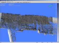
Laser scanning and bathymetric side-scan sonar represent the cutting edge of environmental survey technology. Over the last few years, we have tested the integration of these two methodologies, carrying out...
This site uses cookies. By continuing to use this website, you agree to our Cookies Policy. Agree