IVS Partners with Geomatics Data Solutions
IVS 3D announced its partnership with Geomatics Data Solutions to provide sales, support, and training to Fledermaus clients located on the western coast of North America. With over 25 years...
IVS 3D announced its partnership with Geomatics Data Solutions to provide sales, support, and training to Fledermaus clients located on the western coast of North America. With over 25 years...
Hydrographic Society Russia HSR Honorary Member Jubilee It seems as though it was only recently that HSR members and hydrographers of Russia marked the 80-year birthday of honorary member of...

The latest aerial photography and detailed earth surface models from Bluesky are being used for demonstration in a software package developed to assess the risk and impact of flooding. To...

Andy Hill is key-note speaker at OI 10 in London and convening the Hydrography and Geophysics track of the conference. As Marine Geohazards Technical Authority at BP he states that...

Dutch Dredging has awarded RESON Rotterdam a contract to upgrade their existing Guidance and Monitoring Systems (GMS) aboard the ship TSHD Amazone to that of PDS2000 Hopper. RESON has...
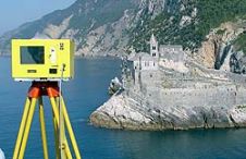
When surveying the coastline, the integration of bathymetric (below sea level) and laser scanning (above sea level) data causes problems due to the different imaging properties. However, by ensuring that...
The dredging and marine contractor Van Oord decided to upgrade their RESON PDS2000 single-beam licenses to full PDS2000 multi-beam licenses. In addition they also purchased the new PDS2000 interactive 3D...
The unique seabed topography of oil & gas field 'Ormen Lange', in the North Sea near Norway makes it very difficult to design pipeline routes and associated structures in compliance...
A jigsaw puzzle of lithospheric plates comprises the outer shell of the earth. Oceanic plates, formed by ascending magma at mid-ocean ridges and transported towards the continents by internal convective...
The Rivers Plate and Paraná in Argentina have much natural sedimentation. In 1993 the Argentine government issued a tender for dredging and signalization of these vital waterways. The concession runs...
This site uses cookies. By continuing to use this website, you agree to our Cookies Policy. Agree