Lidar in surveying & mapping
Lidar, short for Light Detection and Ranging surveying, represents a sophisticated measuring system leveraging the power of light. Widely recognized for its versatility, Lidar is extensively applied in diverse fields...
Lidar, short for Light Detection and Ranging surveying, represents a sophisticated measuring system leveraging the power of light. Widely recognized for its versatility, Lidar is extensively applied in diverse fields...
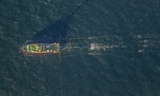
Fugro has secured the geophysical survey contract for the Dutch Doordewind offshore wind farm zone development. Fugro’s selection was driven by its pioneering 2D ultra-ultra-high resolution (UUHR) surveys, delivering unparalleled...
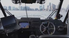
Sea Machines has secured a US$12 million investment from Emerald Technology Ventures, a pioneering cleantech venture capital firm. Joining this funding round are notable investors including Nabtesco Technology Ventures (NTV),...

Three years ago we discussed the global proliferation of large coastal hydrographic charting-based projects. More recently the topic was large, multi-month MBES applications on a variety of regional seabed mapping...
The GeoSpatial Solutions (GSS) division of Merrick & Company has made the new version 6.0 Merrick Advanced Remote Sensing (MARS) software suite available online. Geospatial users interested in evaluating MARS...
All over the world, surveyors are opting for UAV technologies to advance coastal mapping services. VBW Weight GmbH from Germany and RASA Surveying from the Philippines are professional service providers...
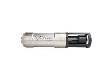
The new SWiFT Deep CTD is the latest in Valeport’s popular range of SWiFT profilers and delivers enhanced accuracy and versatility for those requiring CTD measurements to depths of 6000m. The new SWiFT Deep CTD profiler provides survey-grade sensor technology coupled with the convenience of Bluetooth® wireless technology, a rechargeable battery and an integral GPS module to geo-locate each profile. Ease of...
CARIS has released Bathy DataBASE 2.0 for the creation and management of bathymetric surfaces. Bathy DataBASE was developed to allow hydrographers to overcome obstacles of large bathymetric data sets and...

With innovation, progress and discovery at its heart, Oceanology International 2024 (Oi24) is preparing to welcome the world’s largest gathering of ocean professionals to the most powerful and inspirational event...
This site uses cookies. By continuing to use this website, you agree to our Cookies Policy. Agree