Updating archive data with airborne bathymetric technologies
All over the world, surveyors are opting for UAV technologies to advance coastal mapping services. VBW Weight GmbH from Germany and RASA Surveying from the Philippines are professional service providers with over 25 years of experience in traditional and drone surveying methods. While located in different parts of the world, they face similar customer challenges related to climate change. This year, both companies advanced their services portfolio with UAV-based bathymetry.
Rethinking coastal mapping services
Rising sea levels are pushing local authorities to rethink their monitoring approaches and increasing the speed with which service providers must accommodate coastal management and monitoring demands. As a result, both surveyors and hardware and software producers require new technologies to advance coastal mapping services. One of the key requests made to service providers relates to the collection or updating of coastal archive data, and UAV-based surveying of coastal environments makes it possible to quickly and accurately collect shallow-water data and details on the land-sea interface.
To meet such archive data requests, VBW Weight and RASA Surveying have partnered with TOPODRONE, a Swiss-based designer and manufacturer of high-precision surveying equipment for installation on UAVs, vehicles and backpacks. Together, they conducted successful test flights with TOPODRONE AQUAMAPPER, a bathymetric device mounted to the DJI Matrice 300 drone.
Surveying the Baltic Sea
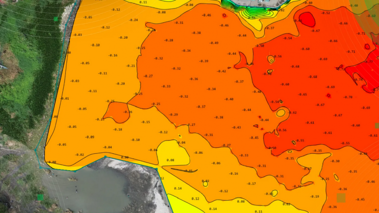
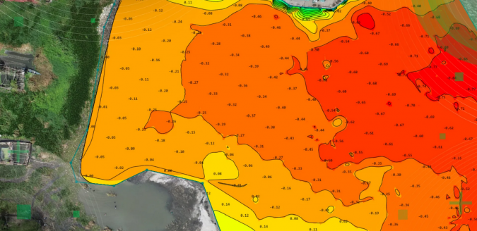
VBW Weight GmbH is a German service provider in the fields of engineering surveying, hydrography (inland waters, nearshore and offshore), geotechnical engineering and satellite geodesy. Located near Rostock on the northern coast of Germany, the company counts almost all the known players in the offshore wind sector among its long-term customers. During one of its recent projects, VBW Weight was tasked with scanning a 360km section of the shoreline to update the existing archive data. Manual coastal mapping of the targeted area had been performed ten years ago.
Part of the project was conducted together with the TOPODRONE team. This included practicing the take-off and landing stages of the TOPODRONE AQUAMAPPER mounted to the DJI Matrice 300 due to the specificity of the operation, plus data processing. The surveyors were presented with challenging conditions, with a wave altitude of 10–40cm and a wind velocity of 5–7m/s.
The raw data was processed in the TOPODRONE Post-Processing software. The team benefited from the possibility to maintain constant flight altitude based on streamed radar data during the flight. For temperature parameters, data from the sensor was used that was obtained during the survey.
Studying coastal cities in the South China sea
RASA Surveying is one of the largest providers of surveying services in the Philippines and provides accurate and high-quality global positioning surveys. The company is recognized locally and internationally as one of the industry’s finest by organizations such as the ASEAN Federation of Land Surveying and Geomatics and Geodetic Engineers of the Philippines (GEP). To overcome local cost and time operational limitations for coastal mapping, the RASA Surveying team has been experimenting with new surveying technologies and approaches, including UAV-based bathymetry.
The City of Cabuyao is known to be vulnerable to the effects of climate-related disasters. To better support authorities in managing the coastline and enhancing the resilience of coastal communities, RASA Surveying has started to apply the TOPODRONE AQUAMAPPER mounted to the DJI M300 and TOPODRONE Post-processing software for GNSS processing and geotagging. The results of a test flight performed in Cabuyao provided the RASA team with the required efficiency for conducting bathymetric surveys, as the team of just two surveyors was able to cover a large survey area within just one working day, collecting accurate elevation and depth data for coastal management and planning.

Value staying current with hydrography?
Stay on the map with our expertly curated newsletters.
We provide educational insights, industry updates, and inspiring stories from the world of hydrography to help you learn, grow, and navigate your field with confidence. Don't miss out - subscribe today and ensure you're always informed, educated, and inspired by the latest in hydrographic technology and research.
Choose your newsletter(s)


