Salman Bashit
Salman Bashit, an urban planning graduate from Khulna University in Bangladesh, is currently furthering his education in Geoscience at Mississippi State University. His academic and professional journey is marked by...

Salman Bashit, an urban planning graduate from Khulna University in Bangladesh, is currently furthering his education in Geoscience at Mississippi State University. His academic and professional journey is marked by...
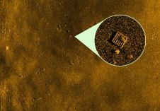
Kongsberg Discovery has unveiled a new analysis tool, developed in collaboration with underwater imaging specialist Cathx Ocean. This innovative tool significantly streamlines the process of detecting and classifying objects of...
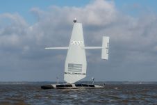
Autonomous vessel experts and artificial intelligence (AI) pioneers behind the first full-size unmanned research vessel to conduct scientific experiments while autonomously navigating the Atlantic Ocean have announced their plans to...
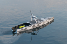
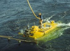
Saildrone announced the launch of its first aluminium Surveyor unmanned surface vehicle (USV) from the Austal USA production line in Mobile, Alabama. Chief of Naval Operations (CNO) Adm. Lisa Franchetti was...
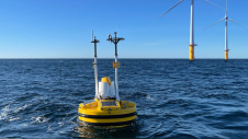
Exail’s DriX uncrewed surface vessel (USV) recently completed a first-of-its-kind fisheries research survey to assess the impact on biomass and fish stock before, during and after wind farm construction. Equipped...

Oceanology International 2024 (Oi24) is set to captivate attendees with a showcase of pioneering companies and innovative technologies, all poised to command attention at London's ExCeL. From advanced autonomous vehicles...

The presence of suspended sediments in water bodies presents significant challenges for the dredging industry. Existing methods to determine nautical depths are intrusive single point methods relying on in situ density or shear strength measurements1,3 or low-frequency single-beam echosounder recordings1,2. The use of single-beam echosounders is however systemically problematic as they are not practical in satisfying the CATZOC A1 coverages required for contemporary electronic navigational charting. The presence of suspended sediments in water bodies presents significant challenges for the dredging industry. Existing methods to determine nautical depths are intrusive single point methods relying on in situ...
The offshore wind industry knows it can do better. While its potential is undeniable, challenges remain and acknowledging its shortcomings is crucial for progress. Oceanology International 2024 aims to confront...
Restricted operating life, limited range and bearing ambiguity in deep water are the known limitations of current locator beacons mounted on aircraft. These problems raise important questions: what is the...
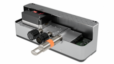
EM 2042 Multibeam Echosounder Small in size, but powerful in potential, the EM 2042 Multibeam Echosounder is efficient, light, robust and reliable: delivering high-density, high-resolution, clean data in the most demanding marine environments. With...
This site uses cookies. By continuing to use this website, you agree to our Cookies Policy. Agree