The evolution of Dutch hydrography
Given the Netherlands’ geographical location, it is unsurprising to find it has a long tradition of hydrography. The lowland, often below sea level, forms a delta where major rivers from...

Given the Netherlands’ geographical location, it is unsurprising to find it has a long tradition of hydrography. The lowland, often below sea level, forms a delta where major rivers from...

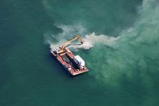
The presence of suspended sediments in water bodies presents significant challenges for the dredging industry. Existing methods to determine nautical depths are intrusive single point methods relying on in situ density or shear strength measurements1,3 or low-frequency single-beam echosounder recordings1,2. The use of single-beam echosounders is however systemically problematic as they are not practical in satisfying the CATZOC A1 coverages required for contemporary electronic navigational charting. The presence of suspended sediments in water bodies presents significant challenges for the dredging industry. Existing methods to determine nautical depths are intrusive single point methods relying on in situ...

IHO standard S-44 is often used (or misused) to specify the quality of a hydrographic survey. While it is a useful tool, it is easy to misinterpret. One ‘misuse’ is...
OceanWise and Foreshore Technology have collaborated to integrate real-time, accurate tide level data into the Dredge Master system, enabling dredging operators to dredge and navigate based on current water levels...
The Hydrographic Society Benelux, together with the dredgers organisation CEDA, assembled on 30 September at the headquarters of Van Oord in Rotterdam, the Netherlands. After a buffet dinner, the participants...
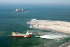
Dredging is essential to the construction or maintenance of much of the infrastructure on which our economic prosperity and social well-being depend. It is also an important tool to restore...
Explore maritime excellence with East Coast Maritime Pty Ltd! As leading marine contractors, our versatile fleet delivers:Port & Channel Maintenance: Expert plough dredging with vessels such as Pacific Conquest and Lismore.Dredging Support: Proven expertise...
This site uses cookies. By continuing to use this website, you agree to our Cookies Policy. Agree