GIS in Mapping Ocean Floor
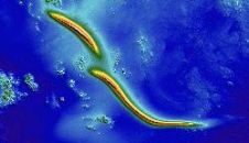
Ocean Globe from ESRI Press examines bathymetry from its early history through today's use of geographic information systems (GIS) and other technologies to map the ocean floor. With contributions from...
Ocean Globe from ESRI Press examines bathymetry from its early history through today's use of geographic information systems (GIS) and other technologies to map the ocean floor. With contributions from...
The UK’s Maritime and Coastguard Agency (MCA) is the national authority responsible for implementing the British Government’s maritime safety policy. Within this remit, the MCA is accountable for delivering national...
The new version of ArcGIS Explorer, a free geographic information system (GIS) viewer, opens more avenues for users to share geographic information. It also has new interoperability updates that help...
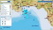
ESRI has created an interactive map containing various sources of information related to the Deepwater Horizon oil Spill near Louisiana, USA. The map indicates the oil areas on the Gulf...
Esri is offering a free, one-day seminar, Increase Productivity with ArcGIS 10, that will benefit professionals in all industries, whether they are working in a desktop, mobile, server, or cloud...
Esri expands the power of geoportals with the release of the ArcGIS Server 10 Geoportal extension. The extension allows organisations to quickly set up websites, called geoportals that help them...
Esri has expanded its mobile geographic information system (GIS) platform to now support the iPhone, iPad, and iPod touch. The new ArcGIS for iOS includes both a free downloadable application...
Hydro International will be at the ESRI User Conference, which is to be held from 12th to 16th July 2010 in San Diego, CA, USA. Publishing director Durk Haarsma and...
Safe Software has expanded its FME Training Programme with the addition of instructor-led online training. This is an option for users who can't afford the time or expense of traveling...
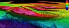
TruDepth Seamless Layer of UK Bathymetry TruDepth survey bathymetry products represent a collection of Digital Terrain Model (DTM) tiles. The models are based on the best available survey data from...
This site uses cookies. By continuing to use this website, you agree to our Cookies Policy. Agree