Keynote by David Gallo at Esri Ocean GIS Forum
David Gallo, PhD, will address the Esri Ocean GIS Forum at Esri headquarters in Redlands, California, USA, from 5-7 November 2013. Gallo is an American oceanographer and the director of...
David Gallo, PhD, will address the Esri Ocean GIS Forum at Esri headquarters in Redlands, California, USA, from 5-7 November 2013. Gallo is an American oceanographer and the director of...

Marine data management and GIS specialist OceanWise has recently delivered its third course on Data Management, Database Design and Marine Spatial Data Infrastructure (MSDI) Capacity Building to the East Asia...
A panel of business, government, conservation and academic leaders has agreed a global strategy for aligning ocean health and human well-being. The Blue Ribbon Panel, which includes 21 global experts...
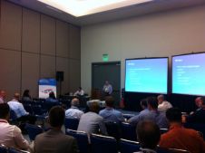
More than 50 users from organisations ranging from the International Hydrographic Bureau (secretariat of the International Hydrographic Organization), NOAA Office of Coast Survey, Danish Geodata Agency (GST), and the Yangtze...
Organised by The Hydrographic Society UK and supported by the International Hydrographic Organization (IHO) and the International Federation of Hydrographic Societies (IFHS), registration is now open for the two-day Digital...
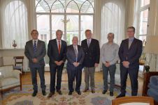
ESRI Belux has donated 50 user licenses of its ArcGIS Online to the Intergovernmental Oceanographic Commission (IOC) Project Office for International Oceanographic Data Exchange (IODE), Ostend, Belgium. To mark the...

A team of shipwreck hunters have turned to advanced 3D mapping technology to locate sunken vessels along the South Australian coastline without getting their feet wet. A group of shipwreck...
Geocap has been taken over by Norway-based Geodata. Geocap specialises in mapping and modelling solutions for use in areas including oil exploration and production. Two years after Geodata acquired GIS-Partner,...
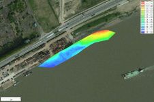
Eye4Software’s hydrographic survey package, Hydromagic version 5.1, has been released. The software maps the bottom of a river, pond or ocean in 3D by using a (D)GPS or RTK positioning...
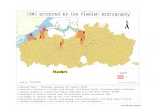
Safety of navigation on inland waterways is as important as in maritime waters. To guarantee this, Electronic Navigational Charts (ENCs) have now been produced for several years. As inland waterways...
This site uses cookies. By continuing to use this website, you agree to our Cookies Policy. Agree